1980s Maps of Calamus, Wisconsin
Explore 5 historic maps of Calamus from the 1980s. These maps offer a rare glimpse into what life looked like during the 1980s — showing old roads, neighborhoods, homes, and landmarks that have changed or disappeared over time.
Whether you're researching your family's past, planning a metal detecting trip, or studying how Calamus's landscape evolved across the 1980s, these high-resolution maps are a powerful tool for exploring the history of this region.
- Focus on a specific era: All maps on this page are from the 1980s, giving you a focused view of this time period.
- See what’s changed: Compare century-old streets, trails, and buildings to today's modern landscape using overlays and satellite layers.
- Research with precision: Use these maps for genealogy, historical research, land use analysis, or educational projects.
- View, download, or print: Maps are fully viewable online in high resolution, and can be downloaded or printed for your own records.
Start exploring Calamus's history through authentic maps from the 1980s. This is your window into the past.
Calamus, WI maps
(5)- 1980 Map of Lost Lake
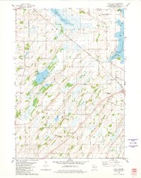 1980 Lost Lake1980 Print · USGSThe rolling lands of Dodge County in the late 1970s reveal a quiet landscape of lakeside settlements and rural townships. Genealogists can locate several family burial grounds including Bethany Cemetery and Salem Cemetery near the waters of Lost Lake.
 - 1980 Map of Columbus, 1981 Print
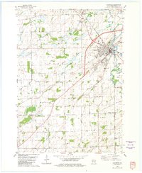 1980 Columbus1981 Print · USGSColumbus and the surrounding townships thrive along the Crawfish River during the early 1980s, where rail and river define the landscape. Local historians can trace family-named roads and rural sites like North York Cem, Townhall, and the Wisconsin Academy.
 - 1980 Map of Fall River, 1981 Print
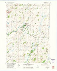
 1980 Fall River1981 Print · USGSFall River and the surrounding Columbia County wetlands appear in this 1980s-era survey during a time of steady agricultural and rail activity. Trace local family history and rural development through landmarks like St Stephen Cem, Courtland Ch, and the Milwaukee Road rail line.
 - 1980 Map of Astico, 1981 Print
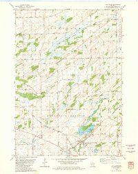
 1980 Astico1981 Print · USGSDodge County's river valleys and rail corridors appear in high detail during the 1980s, centered on the settlement of Astico. Genealogists can locate family landmarks such as Bethel Cem and St Columbkille Ch, or trace the winding Crawfish River.
 - 1984 Map of Oconomowoc, 1985 Print
 1984 Oconomowoc1985 Print · USGSSoutheast Wisconsin in the mid-eighties shows a landscape defined by its glacial heritage and expanding metropolitan corridors. Genealogists and historians can trace the development of lakeside communities like Oconomowoc and Pewaukee, or find established settlements such as Watertown and Beaver Dam.
End of results
Showing maps 1-5 of 5
Top cities near Calamus
- Beaver Dam historical maps
- Watertown historical maps
- Columbus historical maps
- Waupun historical maps
- Waterloo historical maps
- Juneau historical maps
See more
Top neighborhoods of Calamus
Frequently asked questions
- What are the different types of historical maps available for Calamus?
- What is the oldest map of Calamus?
- Where can I purchase historical maps of Calamus for my home or office?
- Where can I download high-res historical maps of Calamus?
- Are there historical topographic maps available for Calamus?
- Is there historical aerial imagery available for Calamus?
- Where are historical maps of Calamus sourced from?