1980s Maps of Highland, Wisconsin
Explore 7 historic maps of Highland from the 1980s. These maps offer a rare glimpse into what life looked like during the 1980s — showing old roads, neighborhoods, homes, and landmarks that have changed or disappeared over time.
Whether you're researching your family's past, planning a metal detecting trip, or studying how Highland's landscape evolved across the 1980s, these high-resolution maps are a powerful tool for exploring the history of this region.
- Focus on a specific era: All maps on this page are from the 1980s, giving you a focused view of this time period.
- See what’s changed: Compare century-old streets, trails, and buildings to today's modern landscape using overlays and satellite layers.
- Research with precision: Use these maps for genealogy, historical research, land use analysis, or educational projects.
- View, download, or print: Maps are fully viewable online in high resolution, and can be downloaded or printed for your own records.
Start exploring Highland's history through authentic maps from the 1980s. This is your window into the past.
Highland, WI maps
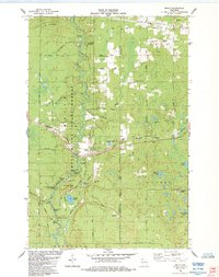
(7)- 1980 Map of Port Wing
 1980 Port Wing1980 Print · USGSThe Lake Superior shoreline and the deep forests of Bayfield and Douglas counties are captured here in the early eighties. Genealogists and historians can trace the rail lines through Iron River or locate the lakeside landings at Cornucopia and Port Wing.
 - 1980 Map of Solon Springs
 1980 Solon Springs1980 Print · USGSNorthern Wisconsin in the early eighties was a landscape of dense timber and sprawling glacial waters. Trace the legacy of the Chicago and North Western rail line through Solon Springs, Hayward, and Minong at this pivotal moment.
 - 1984 Map of Metzger Lake
 1984 Metzger Lake1984 Print · USGSDouglas County’s glacial lakes and timberlands are documented in the mid-1980s, showcasing a network of primitive fire lanes and scenic corridors. Trace the path of the North Country National Scenic Trail and find landmarks like Camp Bovey or the shores of Simms Lake.
 - 1984 Map of Ellison Lake
 1984 Ellison Lake1984 Print · USGSIn the mid-1980s, this portion of Douglas and Bayfield counties shows a dense network of water bodies and local township life. Researchers can trace family history at Barnes Cem or explore early land use near Mooney Dam County Park and the Lookout Tower.
 - 1984 Map of Brule
 1984 Brule1984 Print · USGSIn the mid-1980s, the Brule River valley was a landscape of forestry, fishing, and rail transit. Researchers can trace the Burlington Northern tracks as they pass through Brule or locate local landmarks like Pine Ridge Cem and the State Fish Hatchery.
 - 1984 Map of Lake Minnesuing
 1984 Lake Minnesuing1984 Print · USGSDouglas County’s river-carved timberlands are captured here in the mid-eighties, showing the intersection of state forest conservation and lakeside settlement. You can trace family history at Highland Memorial Cem or follow the Bois Brule River past Stories Bridge Landing and McDougal Springs.
 - 1984 Map of Island Lake
 1984 Island Lake1984 Print · USGSThe Brule River corridor and its famed whitewater rapids define this 1980s survey of the northern Wisconsin woods. Researchers can trace the layout of the Cedar Island Estate, locate the Brule Lookout Tower, and identify dozens of named glacial waters like Lucius Lake.
End of results
Showing maps 1-7 of 7
Top cities near Highland
- Hawthorne historical maps
- Iron River historical maps
- Lake Nebagamon historical maps
- Cable historical maps
- Gordon historical maps
- Wascott historical maps
See more
Frequently asked questions
- What are the different types of historical maps available for Highland?
- What is the oldest map of Highland?
- Where can I purchase historical maps of Highland for my home or office?
- Where can I download high-res historical maps of Highland?
- Are there historical topographic maps available for Highland?
- Is there historical aerial imagery available for Highland?
- Where are historical maps of Highland sourced from?