Old Maps of Sherman, Wisconsin for Academic Research
Study the evolution of Sherman with 33 high-resolution historic maps. Whether you're teaching, researching, or modeling changes in land use, these maps provide essential visual documentation of urban, environmental, and geographic change.
- Analyze long-term change: Track patterns in development, transportation, and natural features.
- Ideal for environmental or urban studies: Support academic projects with primary historical map data.
- Use in the classroom or lab: Educators and researchers rely on these maps to bring historical context to life.
These maps are a powerful tool for teaching, research, and visualizing how Sherman has changed over the decades.
Sherman, WI maps
(33)- 1940 Map of Menomonie, 1965 Print
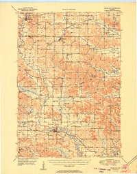
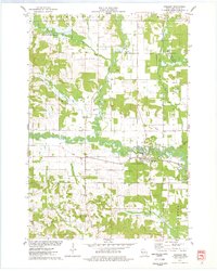
 1940 Menomonie1965 Print · USGSDunn County in the early 1940s is a landscape of established river towns and a dense network of country schoolhouses. Genealogists can trace family roots through sites like Beyer Settlement Sch, Ideal Cem, and the County Asylum.2 unique versions available
 - 1942 Map of Menomonie
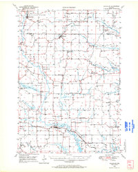
 1942 Menomonie1942 Print · USGSDunn County at the start of the 1940s reveals a region of thriving river towns and closely knit rural school districts. Genealogists can trace family roots through numerous country schools like Knapp Settlement School and local burial grounds such as Sherman Cem.
 - 1946 Map of Knapp, 1967 Print
 1946 Knapp1967 Print · USGSThe borderlands of St. Croix, Pierce, and Dunn Counties come to life in this mid-century survey of the Wisconsin dairy country. Genealogists can locate dozens of country schools like Broadview Sch and Denver Sch, as well as the Dunkard Ch and Teegarden Cem.
 - 1948 Map of Downing, 1970 Print
 1948 Downing1970 Print · USGSWestern Wisconsin's agricultural and rail heartland is captured here in the late 1940s, centered on the villages of the Tiffany Creek valley. Genealogists can trace family roots through dozens of rural landmarks like Beaver Valley Sch, Graytown, and Immanuel Ch.
 - 1949 Map of Knapp
 1949 Knapp1949 Print · USGSDunn, St. Croix, and Pierce counties come together in the late 1940s, showing a landscape defined by small-scale farming and the rail corridor. Genealogists can locate dozens of country schools and churches like Wilson Ch, East Hill Sch, and Hatchville Ch.
 - 1949 Map of Ridgeland, 1970 Print
 1949 Ridgeland1970 Print · USGSThe rural borderlands of Barron and Dunn counties are captured here in the late 1940s, when small-town rail hubs and country schoolhouses still dotted the landscape. Researchers can trace family roots through numerous sites like Evergreen Cem, Vanceburg, and Parkman Sch.
 - 1950 Map of Downing
 1950 Downing1950 Print · USGSWisconsin's dairy and timber heartland is captured here just after the war, centered on the rail-linked towns of Glenwood City and Boyceville. Genealogists can trace family roots through numerous country schools like Peaceful Valley and local landmarks like Chimney Rock.
 - 1951 Map of Ridgeland
 1951 Ridgeland1951 Print · USGSDunn and Barron counties thrive as a network of small-town centers and rural school districts during the early fifties. Genealogists can trace family roots through numerous sites like Lutheran Cem, Zion Ch, and the Little Beaver Sch.
 - 1953 Map of Saint Paul, 1964 Print
 1953 Saint Paul1964 Print · USGSThe Twin Cities and the Mississippi River valley are captured here at a mid-century turning point. Trace the early growth of Minneapolis and Saint Paul alongside landmarks like Lake Minnetonka and the St Croix River.4 unique versions available
 - 1953 Map of Eau Claire, 1965 Print
 1953 Eau Claire1965 Print · USGSWest-central Wisconsin in the mid-fifties shows a landscape of river-valley industry and vast wildlife refuges during the transition from rails to modern highways. Genealogists and historians can trace the rail corridors of the Chicago and North Western or locate family-named landmarks like Decorah Mound and Chippewa Island.4 unique versions available
 - 1953 Map of Rice Lake, 1967 Print
 1953 Rice Lake1967 Print · USGSNorthwest Wisconsin during the mid-fifties reveals a landscape defined by timber, rail, and water. Genealogists and historians can trace the development of river towns like Ladysmith and Rice Lake along the Soo Line and Chicago and North Western railroads.2 unique versions available
 - 1953 Map of Stillwater, 1980 Print
 1953 Stillwater1980 Print · USGSThe Twin Cities and the St. Croix Valley are captured in this mid-century survey as the interstate era began to transform the Upper Midwest. Genealogists and historians can trace the rail-and-river geography of Stillwater, locate landmarks in Anoka, or explore the sprawling St Croix State Park.
 - 1955 Map of Stillwater, 1965 Print
 1955 Stillwater1965 Print · USGSThe Upper St. Croix Valley and the growing Twin Cities area are shown here during the mid-fifties, before the interstate era transformed the regional commute. You can trace the lines of the Northern Pacific RR through towns like Rush City or locate the Saint Croix Indian Reservation.
 - 1958 Map of Stillwater
 1958 Stillwater1958 Print · USGSThe Upper Mississippi and St. Croix River valleys appear in the mid-fifties as the Twin Cities expanded north. Genealogists can locate family landmarks like Oak Park Cem, Saint Michael Church, and the Soo Line RR rail corridors.2 unique versions available
 - 1958 Map of Eau Claire
 1958 Eau Claire1958 Print · USGSWestern Wisconsin in the late fifties shows a landscape of growing regional hubs and massive wildlife refuges. Trace the rail lines of the Chicago and North Western between Eau Claire and Marshfield, or explore the terrain around Iron Mound and Lake Wissota.
 - 1959 Map of Rice Lake
 1959 Rice Lake1959 Print · USGSNorthwest Wisconsin in the late fifties was a land of expanding road networks and deep-seated timber history. Genealogists and historians can trace rail lines like the Soo Line RR and Chicago St Paul Minneapolis and Omaha Ry as they link settlements from Spooner to Medford.
 - 1959 Map of Saint Paul
 1959 Saint Paul1959 Print · USGSThe Twin Cities and southeastern Minnesota appear here in the late fifties, showing the peak of the rail era and post-war suburban growth. Genealogists can trace family footprints near Lake Minnetonka, the Univ Of Minn Rosemount Research Center, or the growing neighborhoods of Richfield.2 unique versions available
 - 1964 Map of Eau Claire
 1964 Eau Claire1964 Print · USGSWest-central Wisconsin in the mid-1960s was a hub of river-driven industry and expanding rail networks. Researchers can trace historic homesteads near Menomonie, follow the Soo Line RR through Marshfield, or explore the grounds of the Camp McCoy Military Reservation.
 - 1965 Map of Stillwater
 1965 Stillwater1965 Print · USGSThe Twin Cities and the St. Croix Valley are mapped here during a period of significant post-war growth and industrial transit. Genealogists and historians can trace rail lines like the Northern Pacific RR through towns such as Rush City, Amery, and Balsam Lake.
 - 1972 Map of Menomonie North, 1975 Print
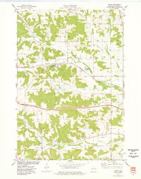
 1972 Menomonie North1975 Print · USGSDunn County in the early seventies shows a landscape of expanding university life and river-based industry. Locate family roots at Sherman Cem, trace the railroad to Menomonie Junction, or study the grounds of Stout State Univ.
 - 1974 Map of Knapp, 1977 Print
 1974 Knapp1977 Print · USGSDunn County farmland and wooded hills surround Knapp in the mid-1970s as the rail line still shapes the local landscape. Genealogists can trace rural roots through family-named landmarks like Teegarden Cem, Mamre Cem, and the Lucas Sch.
 - 1975 Map of Stillwater
 1975 Stillwater1975 Print · USGSThe Twin Cities and the St. Croix Valley are captured in the mid-seventies, showing the urban growth of Minneapolis and St Paul. Researchers can trace old rail corridors of the Northern Pacific RR and locate tribal lands at the Mille Lacs Indian Reservation.2 unique versions available
 - 1975 Map of Boyceville, 1978 Print
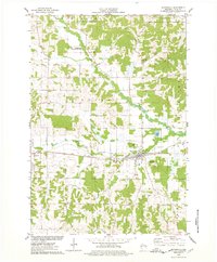 1975 Boyceville1978 Print · USGSThe rural landscape of Dunn County is captured here in the mid-seventies as the SOO LINE still connects the farming communities. Researchers can trace the village layouts of Boyceville and Downing or locate rural sites like Mound Cem and Holy Trinity Ch.
 - 1975 Map of Wheeler, 1978 Print
 1975 Wheeler1978 Print · USGSDunn County life in the mid-seventies centers on the confluence of the Hay River and the Soo Line railroad. Researchers can trace rural landmarks like Hay River Cem, the Church of the Nazarene, and the small settlement of Dewey.
 - 1980 Map of Bloomer
 1980 Bloomer1980 Print · USGSNorthwestern Wisconsin at the start of the eighties shows a landscape deeply connected to its rivers and rail lines. Genealogists and historians can trace the growth of Bloomer, Ladysmith, and Chetek or locate local landmarks like Brunet Island State Park and the Soo Line rail corridors.
Showing maps 1-25 of 33
Top cities near Sherman
- Menomonie historical maps
- Town of Tainter historical maps
- Tainter historical maps
- Town of Red Cedar historical maps
- Red Cedar historical maps
- Glenwood City historical maps
See more
Top neighborhoods of Sherman
Frequently asked questions
- What are the different types of historical maps available for Sherman?
- What is the oldest map of Sherman?
- Where can I purchase historical maps of Sherman for my home or office?
- Where can I download high-res historical maps of Sherman?
- Are there historical topographic maps available for Sherman?
- Is there historical aerial imagery available for Sherman?
- Where are historical maps of Sherman sourced from?