1980s Maps of Manchester, Wisconsin
Explore 6 historic maps of Manchester from the 1980s. These maps offer a rare glimpse into what life looked like during the 1980s — showing old roads, neighborhoods, homes, and landmarks that have changed or disappeared over time.
Whether you're researching your family's past, planning a metal detecting trip, or studying how Manchester's landscape evolved across the 1980s, these high-resolution maps are a powerful tool for exploring the history of this region.
- Focus on a specific era: All maps on this page are from the 1980s, giving you a focused view of this time period.
- See what’s changed: Compare century-old streets, trails, and buildings to today's modern landscape using overlays and satellite layers.
- Research with precision: Use these maps for genealogy, historical research, land use analysis, or educational projects.
- View, download, or print: Maps are fully viewable online in high resolution, and can be downloaded or printed for your own records.
Start exploring Manchester's history through authentic maps from the 1980s. This is your window into the past.
Manchester, WI maps
(6)- 1983 Map of Melrose, 1984 Print
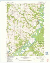 1983 Melrose1984 Print · USGSJackson County river life and rural townships are captured here in the early 1980s. You can trace family plots at St Malachys Cem Ch and follow the winding Black River past Horse Shoe Lake and Irving.
 - 1983 Map of Millston, 1984 Print
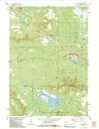 1983 Millston1984 Print · USGSMillston and the surrounding Jackson County wetlands are captured here in the early eighties, showing the town's alignment with the railroad. Researchers can locate Brookside Cem, the industrial Shale Pit, and the extensive Cranberry Bogs.2 unique versions available
 - 1983 Map of Shamrock, 1984 Print
 1983 Shamrock1984 Print · USGSJackson and Monroe County landscapes come together in the early 1980s, centered on the rural crossroads of Shamrock. Genealogists and local historians can trace family-named routes like Kelly Road to find St Calumkille, Gospel Hall, and the scenic Fall Hall Glen.
 - 1984 Map of Stenulson Coulee
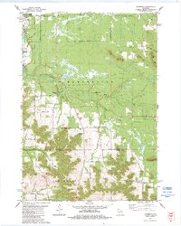
 1984 Stenulson Coulee1984 Print · USGSJackson County agriculture meets the edge of the Black River State Forest in the mid-1980s. Genealogists can locate family burial sites at Stiehl Cem and Pine Creek Cem or trace rural life through landmarks like Charcoal Kilns.
 - 1984 Map of Black River Falls
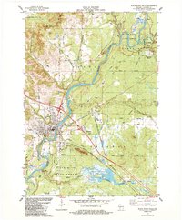 1984 Black River Falls1984 Print · USGSBlack River Falls and the surrounding Jackson County forests are captured in the mid-1980s, showcasing a landscape of river-driven industry and cranberry agriculture. Researchers can trace local roots at Decorah Cem, Gebhardt Sch, and the old rail corridors of the Chicago and North Western.
 - 1985 Map of Black River Falls
 1985 Black River Falls1985 Print · USGSCentral Wisconsin in the mid-1980s is defined by its sprawling wildlife refuges and the winding Black River corridor. Genealogists and researchers can trace rural settlements like Millston and Warrens or locate historical sites such as the Iron Mine and the grounds of Fort McCoy.2 unique versions available
End of results
Showing maps 1-6 of 6
Top cities near Manchester
- Sparta historical maps
- Black River Falls historical maps
- Brockway historical maps
- Angelo historical maps
- Burns historical maps
- Irving historical maps
See more
Top neighborhoods of Manchester
Frequently asked questions
- What are the different types of historical maps available for Manchester?
- What is the oldest map of Manchester?
- Where can I purchase historical maps of Manchester for my home or office?
- Where can I download high-res historical maps of Manchester?
- Are there historical topographic maps available for Manchester?
- Is there historical aerial imagery available for Manchester?
- Where are historical maps of Manchester sourced from?