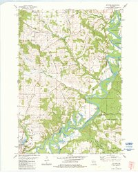
1983 Map of Melrose
USGS Topo · Published 1984About this map
The Black River carves a winding path through this western Wisconsin landscape, defining the boundaries between the townships of Manchester, Irving, and Little Falls. In the early 1980s, the village of Melrose served as a local hub near the confluence of Douglas Creek and the river, while smaller settlements like Irving and Little Norway Ch anchored the surrounding rural community. The terrain is characterized by intricate drainage networks, including Roaring Creek and Robinson Cr, and distinctive features like the Horse Shoe Lake oxbow and the prominent Sugar Loaf elevation.
Find a feature on this map
56 named features on this map. Tap any name to fly to it.
Don’t see what you’re looking for? This feature index may not catch every label — zoom into the map to look around manually.
Map Details
Editions of this 1983 Melrose Map
This is the sole edition of this map. No revisions or reprints were ever made.
Other maps of this area

1924 · Black River Falls
USGS Topo · 1:62,500

1926 · Black River Falls
USGS Topo · 1:62,500

1926 · North Bend
USGS Topo · 1:62,500

1927 · Blair
USGS Topo · 1:62,500

1928 · Melrose
USGS Topo · 1:48,000

1929 · North Bend
USGS Topo · 1:62,500

1949 · Melrose
USGS Topo · 1:62,500

1953 · Eau Claire
USGS Topo · 1:250,000

1958 · Eau Claire
USGS Topo · 1:250,000

1964 · Eau Claire
USGS Topo · 1:250,000