1950s Maps of Lincoln County, Wisconsin
Explore 14 historic maps of Lincoln County from the 1950s. These maps offer a rare glimpse into what life looked like during the 1950s — showing old roads, neighborhoods, homes, and landmarks that have changed or disappeared over time.
Whether you're researching your family's past, planning a metal detecting trip, or studying how Lincoln County's landscape evolved across the 1950s, these high-resolution maps are a powerful tool for exploring the history of this region.
- Focus on a specific era: All maps on this page are from the 1950s, giving you a focused view of this time period.
- See what’s changed: Compare century-old streets, trails, and buildings to today's modern landscape using overlays and satellite layers.
- Research with precision: Use these maps for genealogy, historical research, land use analysis, or educational projects.
- View, download, or print: Maps are fully viewable online in high resolution, and can be downloaded or printed for your own records.
Start exploring Lincoln County's history through authentic maps from the 1950s. This is your window into the past.
Lincoln County, WI maps
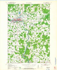
(14)- 1950 Map of Parrish, 1956 Print
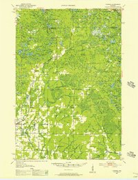 1950 Parrish1956 Print · USGSLanglade and Lincoln Counties are shown in the early fifties as a landscape of timber-era relics and rural immigrant communities. Researchers can trace the Old Railroad Grade and locate cultural landmarks like the Estonian Ch or the Liberty Bell Sch.2 unique versions available
 - 1950 Map of Tomahawk, 1956 Print
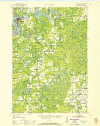 1950 Tomahawk1956 Print · USGSThe river and rail networks of Lincoln County are captured here in the early fifties, centering on the industrial activity of the Wisconsin River. Genealogists and historians can trace family roots through numerous country schools and cemeteries like Calvary Cemetery, Little Pine Creek School, and the settlement at Irma.
 - 1950 Map of Spirit Falls, 1957 Print
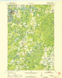
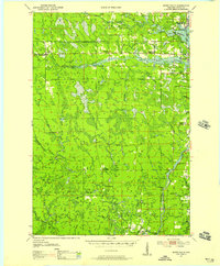 1950 Spirit Falls1957 Print · USGSLincoln County’s river valleys and timberlands are captured here in the early 1950s, documenting the era of hydroelectric power and forest management. Genealogists and historians can trace Old Railroad Grade, remote outposts like Camp 25, and local landmarks like Grandfather Falls.2 unique versions available
 - 1951 Map of Doering, 1954 Print
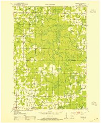 1951 Doering1954 Print · USGSNorthwoods rural life is captured here in the early fifties across the intersection of Lincoln, Langlade, and Marathon counties. Genealogists can trace family footprints near Nutterville, Kalinke, and several country schools like Farrell Sch.2 unique versions available
 - 1951 Map of Athens, 1954 Print
 1951 Athens1954 Print · USGSMarathon and Taylor Counties are captured here in the early fifties, showing a rural landscape organized around the Soo Line railroad. Genealogists can locate dozens of country schools and churches like St Peter Ch, Goodrich Ch, and Corinth Sch.2 unique versions available
 - 1951 Map of Merrill, 1954 Print
 1951 Merrill1954 Print · USGSThe Wisconsin River valley comes alive in this midcentury survey, showing the growth of Merrill and the paper mill life at Brokaw. Genealogists can trace family roots through numerous rural landmarks like Dutch Corners, St James Cem, and the Taegesville Sch.
 - 1951 Map of Hamburg, 1969 Print
 1951 Hamburg1969 Print · USGSThe rural borderlands of Lincoln and Marathon counties come alive in this mid-century survey of Wisconsin dairy country. Genealogists and historians can trace family-named sites like the Lueck Cem, Mitchell Sch, and the unique crossroads of Little Chicago.
 - 1952 Map of Parrish
 1952 Parrish1952 Print · USGSLanglade and Lincoln Counties are shown in the early fifties during a period of transition for Northwoods timber and farming communities. You can trace early ethnic heritage through the Estonian Ch, locate old logging routes like the old railroad grade, and find schools like Good Luck Sch.
 - 1952 Map of Spirit Falls
 1952 Spirit Falls1952 Print · USGSLincoln County is captured during its mid-century transition from a timber-driven frontier to an era of hydroelectric power. Genealogists and researchers can trace rural school locations like Mitchell Sch and industrial sites including Averill Junction and the Grandfather Dam.
 - 1952 Map of Tomahawk
 1952 Tomahawk1952 Print · USGSWisconsin's timber country comes into focus in the early fifties as the river-driven economy of Lincoln County transitions toward modernization. Genealogists and historians can locate rural landmarks like Irma, the Dotter Sch (Abandoned), and Calvary Cem.
 - 1953 Map of Rice Lake, 1967 Print
 1953 Rice Lake1967 Print · USGSNorthwest Wisconsin during the mid-fifties reveals a landscape defined by timber, rail, and water. Genealogists and historians can trace the development of river towns like Ladysmith and Rice Lake along the Soo Line and Chicago and North Western railroads.2 unique versions available
 - 1954 Map of Iron Mountain, 1964 Print
 1954 Iron Mountain1964 Print · USGSUpper Michigan and Northeastern Wisconsin are shown in detail during the mid-fifties, when the logging and mining economies still moved by rail. Trace the rail lines of the Soo Line to remote stops like Koepenick Station or explore the Iron Range near Iron Mountain.2 unique versions available
 - 1959 Map of Rice Lake
 1959 Rice Lake1959 Print · USGSNorthwest Wisconsin in the late fifties was a land of expanding road networks and deep-seated timber history. Genealogists and historians can trace rail lines like the Soo Line RR and Chicago St Paul Minneapolis and Omaha Ry as they link settlements from Spooner to Medford.
 - 1959 Map of Iron Mountain
 1959 Iron Mountain1959 Print · USGSThe northwoods of Wisconsin and the Michigan border are captured here in the mid-fifties, showing a landscape defined by timber, water, and rail. Researchers can trace historic junctions like Hiles Junction, the expansive Nicolet National Forest, and lakefront settlements from Rhinelander to Tomahawk.2 unique versions available
End of results
Showing maps 1-14 of 14
Top cities of Lincoln County
- Merrill historical maps
- Tomahawk historical maps
- Bradley historical maps
- Pine River historical maps
- Harrison historical maps
Frequently asked questions
- What are the different types of historical maps available for Lincoln County?
- What is the oldest map of Lincoln County?
- Where can I purchase historical maps of Lincoln County for my home or office?
- Where can I download high-res historical maps of Lincoln County?
- Are there historical topographic maps available for Lincoln County?
- Is there historical aerial imagery available for Lincoln County?
- Where are historical maps of Lincoln County sourced from?