1970s Maps of Lincoln County, Wisconsin
Explore 17 historic maps of Lincoln County from the 1970s. These maps offer a rare glimpse into what life looked like during the 1970s — showing old roads, neighborhoods, homes, and landmarks that have changed or disappeared over time.
Whether you're researching your family's past, planning a metal detecting trip, or studying how Lincoln County's landscape evolved across the 1970s, these high-resolution maps are a powerful tool for exploring the history of this region.
- Focus on a specific era: All maps on this page are from the 1970s, giving you a focused view of this time period.
- See what’s changed: Compare century-old streets, trails, and buildings to today's modern landscape using overlays and satellite layers.
- Research with precision: Use these maps for genealogy, historical research, land use analysis, or educational projects.
- View, download, or print: Maps are fully viewable online in high resolution, and can be downloaded or printed for your own records.
Start exploring Lincoln County's history through authentic maps from the 1970s. This is your window into the past.
Lincoln County, WI maps
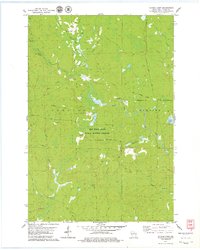
(17)- 1971 Map of Tripoli, 1973 Print
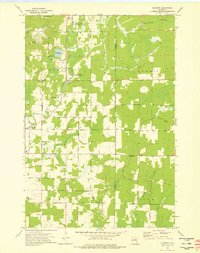
 1971 Tripoli1973 Print · USGSThe town of Tripoli and the surrounding woodlands come alive in this early 1970s survey of the Oneida and Lincoln county line. Researchers can trace the path of the SOO LINE railroad or locate local landmarks like the Wilson School and the shores of Somo Lake.
 - 1971 Map of Bradley, 1973 Print
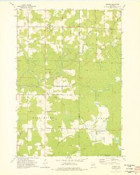
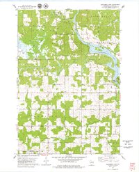
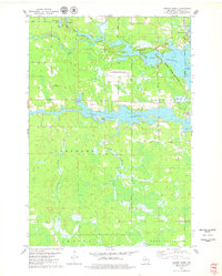
 1971 Bradley1973 Print · USGSOneida and Lincoln Counties are captured here in the early seventies, a landscape shaped by the Little Rice River and the expanding Lake Nokomis flowage. Researchers can trace the Soo Line railroad through Bradley or locate the Prairie Rapids Cem amidst the northwoods lakeside drives.
 - 1973 Map of Gleason, 1976 Print
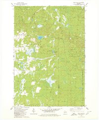
 1973 Gleason1976 Print · USGSLincoln County's rural townships are captured in the early 1970s, showing a landscape defined by the Prairie River and historic immigrant settlements. Researchers can locate the Estonian Cem, Latvian Cem, and follow the Old Railroad Grade through the Northwoods.2 unique versions available
 - 1973 Map of Kalinke, 1976 Print
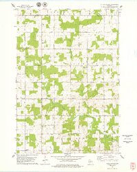
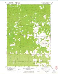
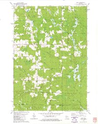
 1973 Kalinke1976 Print · USGSIn the early 1970s, the rural crossroads of Marathon County supported a quiet network of family farms and river-fed wetlands. Genealogists and local historians can locate early institutions like Zion Ch, Trinity Cem, and the Hewitt Texas Sch.
 - 1973 Map of Doering, 1976 Print
 1973 Doering1976 Print · USGSThe northern woods of Lincoln County come to life in this mid-seventies survey of the area around Doering. Genealogists and historians can trace the Old Railroad Grade past Wildwood Ch and find family names at Forest View Cem.
 - 1973 Map of Parrish, 1976 Print
 1973 Parrish1976 Print · USGSNorthern Wisconsin lake country in the 1970s is defined by its glacial terrain and timber history. Researchers can locate the Parrish Cem, trace the Old Railroad Grade, and explore the vast Prairie River State Public Hunting and Fishing Area.2 unique versions available
 - 1978 Map of Grandfather Falls
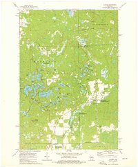
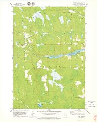
 1978 Grandfather Falls1978 Print · USGSThe Wisconsin River corridor in Lincoln County comes alive in this late 1970s survey, showing the powerhouse operations at Grandfather Falls. Researchers can trace the Old Railroad Grade or locate historic recreation sites like the School Camp.2 unique versions available
 - 1978 Map of Hamburg, 1979 Print
 1978 Hamburg1979 Print · USGSMarathon County in the late seventies is a landscape of river confluences and quiet rural crossroads. Genealogists and local historians can locate early family landmarks like St Pauls Cem, the Hamburg PO, and Salem Ch along the banks of the Rib River.
 - 1978 Map of Little Chicago, 1979 Print
 1978 Little Chicago1979 Print · USGSMarathon County in the late seventies is captured here as a patchwork of active dairy farms and small townships. Researchers can trace family roots through numerous sites like Maple Grove Sch, Big Hill Cem, and the rural community of Naugart.2 unique versions available
 - 1978 Map of Natzke Camp, 1979 Print
 1978 Natzke Camp1979 Print · USGSLincoln County in the late 1970s remained a landscape deeply tied to its logging roots and conservation lands. Genealogists and historians can trace the paths of an Old Railroad Grade or locate historical forest sites like Natzke Camp and Camp 27.
 - 1978 Map of Alexander Lake, 1979 Print
 1978 Alexander Lake1979 Print · USGSLincoln County’s riverfront and marshlands are captured here in the late seventies as rural townships expanded west of Merrill. Genealogists and local historians can trace family-named roads and landmarks like St Pauls Cem, Scott Sch, and the Cranberry Bog.
 - 1978 Map of Fromm Lookout Tower, 1979 Print
 1978 Fromm Lookout Tower1979 Print · USGSLincoln County timberlands and river forks come into focus in the late 1970s. Trace old logging routes along the Old Railroad Grade or locate local landmarks like the Fromm Lookout Tower and Immanuel Ch.
 - 1978 Map of Spirit Falls, 1979 Print
 1978 Spirit Falls1979 Print · USGSLincoln County in the late 1970s remains a landscape defined by its timber heritage and winding waterways. Genealogists and local historians can trace the Old Railroad Grade through the townships or locate the remote settlement of Spirit Falls near the Spirit River Flowage.2 unique versions available
 - 1978 Map of Coffee Creek, 1979 Print
 1978 Coffee Creek1979 Print · USGSLincoln County’s river-driven landscape is captured here in the late seventies, centered on the confluence of the Wisconsin and Spirit rivers. Genealogists and local historians can trace family-named roads and rural landmarks like Wilson School, the Zenith Lookout Tower, and the Cranberry Bog.2 unique versions available
 - 1979 Map of Spirit, 1980 Print
 1979 Spirit1980 Print · USGSThe township of Spirit and its surrounding rural countryside are captured in the late seventies as a community of small farms and timberlands. Local historians can trace old homestead access via Settlement Road, visit the Hillcrest Cem, and locate the Old Railroad Grade near Squaw Creek.2 unique versions available
 - 1979 Map of Wood Lake, 1980 Print
 1979 Wood Lake1980 Print · USGSTaylor and Lincoln Counties appear in the late seventies as a landscape of timber-era remnants and sprawling wetlands. Genealogists and historians can trace the Old Railroad Grade and Old RR GR through the terrain near Wood Lake and Camp Eight Flowage.2 unique versions available
 - 1979 Map of Brantwood, 1980 Print
 1979 Brantwood1980 Print · USGSThe Northwoods landscape near the Price and Oneida county lines is captured here in the late seventies, centered on the Soo Line rail corridor. Genealogists and local historians can trace old homesteads and community sites like the Finnish Cem, Tripoli Sch, and the settlement of Brantwood.
End of results
Showing maps 1-17 of 17
Top cities of Lincoln County
- Merrill historical maps
- Tomahawk historical maps
- Bradley historical maps
- Pine River historical maps
- Harrison historical maps
Frequently asked questions
- What are the different types of historical maps available for Lincoln County?
- What is the oldest map of Lincoln County?
- Where can I purchase historical maps of Lincoln County for my home or office?
- Where can I download high-res historical maps of Lincoln County?
- Are there historical topographic maps available for Lincoln County?
- Is there historical aerial imagery available for Lincoln County?
- Where are historical maps of Lincoln County sourced from?