1950s Maps of Oneida County, Wisconsin
Explore 11 historic maps of Oneida County from the 1950s. These maps offer a rare glimpse into what life looked like during the 1950s — showing old roads, neighborhoods, homes, and landmarks that have changed or disappeared over time.
Whether you're researching your family's past, planning a metal detecting trip, or studying how Oneida County's landscape evolved across the 1950s, these high-resolution maps are a powerful tool for exploring the history of this region.
- Focus on a specific era: All maps on this page are from the 1950s, giving you a focused view of this time period.
- See what’s changed: Compare century-old streets, trails, and buildings to today's modern landscape using overlays and satellite layers.
- Research with precision: Use these maps for genealogy, historical research, land use analysis, or educational projects.
- View, download, or print: Maps are fully viewable online in high resolution, and can be downloaded or printed for your own records.
Start exploring Oneida County's history through authentic maps from the 1950s. This is your window into the past.
Oneida County, WI maps
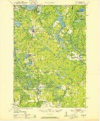
(11)- 1950 Map of Pike Lake
 1950 Pike Lake1950 Print · USGSNorthern Wisconsin's timber and lake country comes to life in the mid-century, showing a landscape shaped by conservation and seasonal recreation. Local historians can trace the locations of the Riley Creek CCC Camp, Shady Knoll Sch, and numerous family-named landmarks like Patterson Lake.
 - 1950 Map of Lac Du Flambeau
 1950 Lac Du Flambeau1950 Print · USGSThe northern lake country of Vilas and Oneida Counties is captured here at mid-century, centered on the Lac du Flambeau reservation. Researchers can trace the old Chicago and Northwestern rail line and locate landmarks like the Marlands Sch or the Flambeau Fire Tower.
 - 1950 Map of Monico
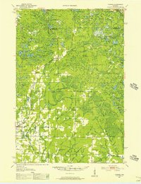
 1950 Monico1950 Print · USGSOneida County at mid-century is a landscape of glacial lakes and critical rail junctions during the height of the timber and transport era. Researchers can trace rural school locations like Wolf River Sch and rail outposts including Starks, Gagen, and Lennox.
 - 1950 Map of Elcho, 1952 Print
 1950 Elcho1952 Print · USGSLanglade and Oneida Counties come into focus during the early fifties, a time when the Chicago and North Western railway still connected these timber-rich lakeside communities. You can trace early township schools like Enterprise Sch, find the Pence Lake Lookout Tower, and locate vanished landmarks along the Old Railroad Grade.3 unique versions available
 - 1950 Map of Parrish, 1956 Print
 1950 Parrish1956 Print · USGSLanglade and Lincoln Counties are shown in the early fifties as a landscape of timber-era relics and rural immigrant communities. Researchers can trace the Old Railroad Grade and locate cultural landmarks like the Estonian Ch or the Liberty Bell Sch.2 unique versions available
 - 1951 Map of Lac Du Flambeau
 1951 Lac Du Flambeau1951 Print · USGSNorthern Wisconsin's lake country is captured here during the mid-century, showing the established communities of the Flambeau area. Genealogists and local historians can trace the Chicago and Northwestern rail line and find sites like Marlands Sch or the Flambeau Fire Tower.
 - 1952 Map of Parrish
 1952 Parrish1952 Print · USGSLanglade and Lincoln Counties are shown in the early fifties during a period of transition for Northwoods timber and farming communities. You can trace early ethnic heritage through the Estonian Ch, locate old logging routes like the old railroad grade, and find schools like Good Luck Sch.
 - 1953 Map of Rice Lake, 1967 Print
 1953 Rice Lake1967 Print · USGSNorthwest Wisconsin during the mid-fifties reveals a landscape defined by timber, rail, and water. Genealogists and historians can trace the development of river towns like Ladysmith and Rice Lake along the Soo Line and Chicago and North Western railroads.2 unique versions available
 - 1954 Map of Iron Mountain, 1964 Print
 1954 Iron Mountain1964 Print · USGSUpper Michigan and Northeastern Wisconsin are shown in detail during the mid-fifties, when the logging and mining economies still moved by rail. Trace the rail lines of the Soo Line to remote stops like Koepenick Station or explore the Iron Range near Iron Mountain.2 unique versions available
 - 1959 Map of Rice Lake
 1959 Rice Lake1959 Print · USGSNorthwest Wisconsin in the late fifties was a land of expanding road networks and deep-seated timber history. Genealogists and historians can trace rail lines like the Soo Line RR and Chicago St Paul Minneapolis and Omaha Ry as they link settlements from Spooner to Medford.
 - 1959 Map of Iron Mountain
 1959 Iron Mountain1959 Print · USGSThe northwoods of Wisconsin and the Michigan border are captured here in the mid-fifties, showing a landscape defined by timber, water, and rail. Researchers can trace historic junctions like Hiles Junction, the expansive Nicolet National Forest, and lakefront settlements from Rhinelander to Tomahawk.2 unique versions available
End of results
Showing maps 1-11 of 11
Top cities of Oneida County
- Rhinelander historical maps
- Minocqua historical maps
- Newbold historical maps
- Three Lakes historical maps
- Sugar Camp historical maps
- Hazelhurst historical maps
See more
Frequently asked questions
- What are the different types of historical maps available for Oneida County?
- What is the oldest map of Oneida County?
- Where can I purchase historical maps of Oneida County for my home or office?
- Where can I download high-res historical maps of Oneida County?
- Are there historical topographic maps available for Oneida County?
- Is there historical aerial imagery available for Oneida County?
- Where are historical maps of Oneida County sourced from?