1960s Maps of Oneida County, Wisconsin
Explore 7 historic maps of Oneida County from the 1960s. These maps offer a rare glimpse into what life looked like during the 1960s — showing old roads, neighborhoods, homes, and landmarks that have changed or disappeared over time.
Whether you're researching your family's past, planning a metal detecting trip, or studying how Oneida County's landscape evolved across the 1960s, these high-resolution maps are a powerful tool for exploring the history of this region.
- Focus on a specific era: All maps on this page are from the 1960s, giving you a focused view of this time period.
- See what’s changed: Compare century-old streets, trails, and buildings to today's modern landscape using overlays and satellite layers.
- Research with precision: Use these maps for genealogy, historical research, land use analysis, or educational projects.
- View, download, or print: Maps are fully viewable online in high resolution, and can be downloaded or printed for your own records.
Start exploring Oneida County's history through authentic maps from the 1960s. This is your window into the past.
Oneida County, WI maps
(7)- 1965 Map of Monico NE, 1966 Print
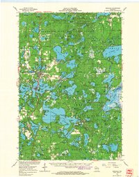
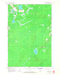 1965 Monico NE1966 Print · USGSOneida County in the mid-1960s remains a landscape of deep timber and glacial water at the edge of the Nicolet National Forest. Genealogists and historians can trace the rail-reliant community of Atkins and early agricultural sites like the Cranberry Bogs near Three Lakes.2 unique versions available
 - 1965 Map of Nashville, 1966 Print
 1965 Nashville1966 Print · USGSOneida and Forest counties in the mid-sixties show a landscape of timber-country settlements and glacial lakes. Genealogists can trace family names at Nashville Cem or Wolfram Cem, while industrial historians can follow the Old Railroad Grade.2 unique versions available
 - 1965 Map of Starks, 1966 Print
 1965 Starks1966 Print · USGSOneida County's Northwoods character is on full display in the mid-sixties, defined by its rail junctions and glacial lake basins. Genealogists and local historians can trace the foundations of Starks and Gagen, noting the locations of Stella Sch and Townhall.2 unique versions available
 - 1965 Map of Monico, 1967 Print
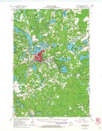
 1965 Monico1967 Print · USGSOneida County's Northwoods landscape is captured here in the mid-1960s, centered on the rail-junction town of Monico. Genealogists and historians can trace the paths of the Chicago and North Western railway or locate landmarks like Pentecost Ch and the Beck Lookout Tower.
 - 1966 Map of Rhinelander, 1968 Print
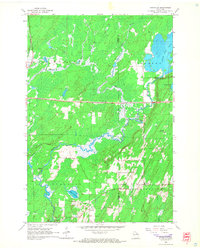
 1966 Rhinelander1968 Print · USGSMid-century Rhinelander is captured here at the intersection of major rail lines and a dense network of glacial lakes. Local historians can trace the footprints of old rural schools like Pine Lake Sch, find early neighborhood churches such as Our Saviour Ch, and locate family sites near Roosevelt or Malvern.
 - 1966 Map of Minocqua, 1968 Print
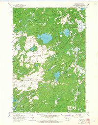
 1966 Minocqua1968 Print · USGSThe Northwoods of Wisconsin are shown in the mid-1960s, documenting a premier lake-resort region centered on Minocqua and Woodruff. Researchers can trace old rail lines like the MILWAUKEE ROAD, explore family-named landmarks like Olmstead Island, or find vanished local sites such as the Drive-in Theater.2 unique versions available
 - 1966 Map of Heafford Junction, 1968 Print
 1966 Heafford Junction1968 Print · USGSOneida County's lake-rich timberlands are documented here in the mid-1960s, showing a landscape defined by rail junctions and glacial waters. Genealogists and local historians can locate the Cassian-Woodboro Sch Cem, the old Nekomis Sch, and rail-side stops like Heafford Junction.
End of results
Showing maps 1-7 of 7
Top cities of Oneida County
- Rhinelander historical maps
- Minocqua historical maps
- Newbold historical maps
- Three Lakes historical maps
- Sugar Camp historical maps
- Hazelhurst historical maps
See more
Frequently asked questions
- What are the different types of historical maps available for Oneida County?
- What is the oldest map of Oneida County?
- Where can I purchase historical maps of Oneida County for my home or office?
- Where can I download high-res historical maps of Oneida County?
- Are there historical topographic maps available for Oneida County?
- Is there historical aerial imagery available for Oneida County?
- Where are historical maps of Oneida County sourced from?