1980s Maps of Oneida County, Wisconsin
Explore 15 historic maps of Oneida County from the 1980s. These maps offer a rare glimpse into what life looked like during the 1980s — showing old roads, neighborhoods, homes, and landmarks that have changed or disappeared over time.
Whether you're researching your family's past, planning a metal detecting trip, or studying how Oneida County's landscape evolved across the 1980s, these high-resolution maps are a powerful tool for exploring the history of this region.
- Focus on a specific era: All maps on this page are from the 1980s, giving you a focused view of this time period.
- See what’s changed: Compare century-old streets, trails, and buildings to today's modern landscape using overlays and satellite layers.
- Research with precision: Use these maps for genealogy, historical research, land use analysis, or educational projects.
- View, download, or print: Maps are fully viewable online in high resolution, and can be downloaded or printed for your own records.
Start exploring Oneida County's history through authentic maps from the 1980s. This is your window into the past.
Oneida County, WI maps
(15)- 1980 Map of Thunder Creek
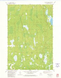 1980 Thunder Creek1980 Print · USGSPrice and Oneida counties are captured in the late seventies, showing a landscape defined by the deep woods of the Chequamegon National Forest. Researchers can trace the path of the Old Railroad Grade and locate features like Dover or the winding Willow River.3 unique versions available
 - 1980 Map of Park Falls
 1980 Park Falls1980 Print · USGSNorthern Wisconsin's timber and rail corridor is meticulously detailed here in the early eighties. Researchers can trace the Soo Line through forest-bound towns like Park Falls, Phillips, and Lugerville while exploring the vast Chequamegon National Forest.
 - 1982 Map of Heafford Junction, 1983 Print
 1982 Heafford Junction1983 Print · USGSOneida and Lincoln Counties are defined by a vast network of glacial water in the early eighties. You can trace the railroad history of Heafford Junction and locate local landmarks like Hiawatha Sch and the Inshalla Country Club.
 - 1982 Map of Lake Tomahawk, 1983 Print
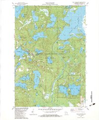 1982 Lake Tomahawk1983 Print · USGSNorthern Oneida County is shown here in the early eighties as a thriving Northwoods destination dominated by the Northern Highland-American Legion State Forest. Researchers can trace the community of Lake Tomahawk, the Newbold Mem Cem, and landmarks like the Tomahawk Lookout Tower.
 - 1982 Map of Sayner, 1983 Print
 1982 Sayner1983 Print · USGSVilas and Oneida counties are captured here in the early eighties as a thriving outdoor recreation area defined by the Northern Highland forest. Trace local landmarks like the Sayner Post Office, St Marys Ch, and the winding Old Railroad Grade.2 unique versions available
 - 1982 Map of Harshaw, 1983 Print
 1982 Harshaw1983 Print · USGSOneida County's Northwoods are captured here in the early eighties as former rail corridors began their transition into recreational trails. Discover the locations of the Union Grove Cem, the settlement of Harshaw, and the Cassian-Woodboro Sch.
 - 1982 Map of Rhinelander, 1983 Print
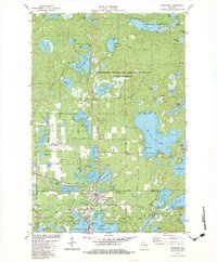
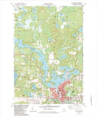 1982 Rhinelander1983 Print · USGSRhinelander and the surrounding lake country of Oneida County are captured here in the early eighties, showcasing a region defined by its timber and water heritage. Genealogists and local researchers can locate landmarks like St Marys Cemetery, Pioneer Park, and the historic Chicago and Northwestern rail line.
 - 1982 Map of Woodboro, 1983 Print
 1982 Woodboro1983 Print · USGSOneida County's lakeland landscape is captured here in the early eighties as a hub for Northwoods recreation and settlement. Researchers can trace family history at the Woodboro Cem or locate seasonal landmarks like Ski Lifts and Whirlpool Rapids along the Wisconsin River.
 - 1982 Map of Mc Naughton, 1983 Print
 1982 Mc Naughton1983 Print · USGSOneida County's Northwoods landscape is captured here in the early eighties, showcasing a dense network of glacial lakes and state-protected timberlands. Genealogists and local historians can locate McNaughton, trace the Pine Grove Landing Field, and identify family-named sites near Mildred Lake.
 - 1982 Map of Lake Julia, 1983 Print
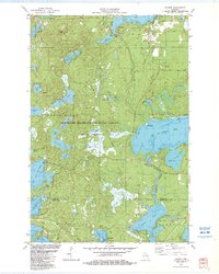
 1982 Lake Julia1983 Print · USGSOneida and Lincoln counties come together in this early 1980s portrait of the Wisconsin Northwoods, where recreation and industry meet. Researchers can pinpoint Nicolet College, the Powerplant at the rapids, and local landmarks like Our Saviour Ch and Almon County Park.
 - 1982 Map of Moen Lake, 1983 Print
 1982 Moen Lake1983 Print · USGSOneida County's northwoods were a complex network of glacial lakes and small settlements in the early eighties. Genealogists and historians can trace the Soo Line rail corridor through Roosevelt and locate landmarks like the Foursquare Ch and Sowinski Landing Field.
 - 1982 Map of George Lake, 1983 Print
 1982 George Lake1983 Print · USGSOneida County's Northwoods landscape is captured here in the early eighties, defined by a dense network of glacial lakes and the winding Pelican River. Researchers can trace the boundaries of the County Forest or locate family landmarks near George Lake, Clear Lake, and Shingle Mill Lake.
 - 1982 Map of Woodruff, 1983 Print
 1982 Woodruff1983 Print · USGSNorthern Wisconsin lake country comes to life in the early eighties, showing the growing communities of Woodruff and Minocqua. Trace local family landmarks like Trinity Ch, the Fish Hatchery, and the historic Milwaukee Road rail line.
 - 1982 Map of Hazelhurst, 1983 Print
 1982 Hazelhurst1983 Print · USGSThe Lakeland region of Oneida County is captured here in the early eighties, showcasing a landscape of dense forests and interconnected waters. Local historians can trace the Bearskin State Park Trail along its Abandoned Railroad route or locate the Lakeside Cem and Minocqua-Hazelhurst Sch.
 - 1989 Map of Rhinelander, 1990 Print
 1989 Rhinelander1990 Print · USGSThe Wisconsin Northwoods are captured here in the late eighties, showing a landscape defined by water and timber management. Researchers can trace the Soo Line rail corridors and find local landmarks like Rainbow Flowage, Pelican Lake, and the Rhinelander-Oneida Co Airport.
End of results
Showing maps 1-15 of 15
Top cities of Oneida County
- Rhinelander historical maps
- Minocqua historical maps
- Newbold historical maps
- Three Lakes historical maps
- Sugar Camp historical maps
- Hazelhurst historical maps
See more
Frequently asked questions
- What are the different types of historical maps available for Oneida County?
- What is the oldest map of Oneida County?
- Where can I purchase historical maps of Oneida County for my home or office?
- Where can I download high-res historical maps of Oneida County?
- Are there historical topographic maps available for Oneida County?
- Is there historical aerial imagery available for Oneida County?
- Where are historical maps of Oneida County sourced from?