1970s Maps of Oneida County, Wisconsin
Explore 23 historic maps of Oneida County from the 1970s. These maps offer a rare glimpse into what life looked like during the 1970s — showing old roads, neighborhoods, homes, and landmarks that have changed or disappeared over time.
Whether you're researching your family's past, planning a metal detecting trip, or studying how Oneida County's landscape evolved across the 1970s, these high-resolution maps are a powerful tool for exploring the history of this region.
- Focus on a specific era: All maps on this page are from the 1970s, giving you a focused view of this time period.
- See what’s changed: Compare century-old streets, trails, and buildings to today's modern landscape using overlays and satellite layers.
- Research with precision: Use these maps for genealogy, historical research, land use analysis, or educational projects.
- View, download, or print: Maps are fully viewable online in high resolution, and can be downloaded or printed for your own records.
Start exploring Oneida County's history through authentic maps from the 1970s. This is your window into the past.
Oneida County, WI maps
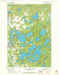
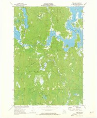
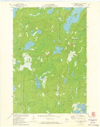
(23)- 1970 Map of Sugar Camp, 1972 Print
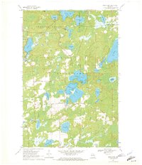 1970 Sugar Camp1972 Print · USGSOneida County's lake-studded landscape is captured here in the early seventies, centered on the settlement of Sugar Camp. Local historians and genealogists can trace property lines near Sugar Camp Lake, locate the Indian Lookout Tower, and explore the northern woods of the American Legion State Forest.2 unique versions available
 - 1970 Map of Eagle River West, 1972 Print
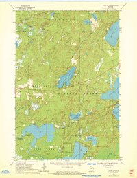
 1970 Eagle River West1972 Print · USGSVilas and Oneida Counties appear here as a interconnected network of Northwoods lakes and timberlands during the early 1970s. Trace the industrial and civic landscape through the Chicago and North Western rail line, the Otter Rapids Dam, and the Fairground.2 unique versions available
 - 1970 Map of Three Lakes, 1972 Print
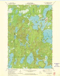
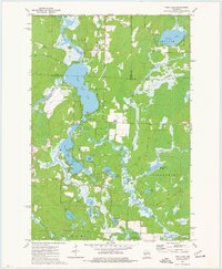
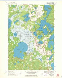 1970 Three Lakes1972 Print · USGSOneida County's lake country is captured here in the early seventies, showcasing a landscape of sprawling wetlands and growing lakeside communities. Genealogists and historians can trace the Chicago and North Western rail line and locate landmarks like the Seventh Day Adventist church or the Drive-in Theater.2 unique versions available
 - 1970 Map of Dam Lake, 1972 Print
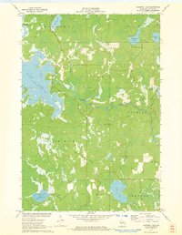
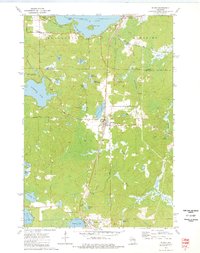
 1970 Dam Lake1972 Print · USGSOneida County's Northwoods are captured here in the early seventies, showing a landscape defined by glacial lakes and the managed waters of the Rainbow Flowage. Local historians and genealogists can trace family-named features like Jenny Barnes Lake or the commercial Cranberry Bog.2 unique versions available
 - 1970 Map of Eagle River East, 1972 Print
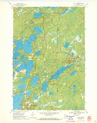
 1970 Eagle River East1972 Print · USGSThe Eagle River chain of lakes is shown here at the height of its mid-century recreation era, centered on the historic town and rail line. Researchers can trace the development of the shoreline through many named summer camps and landmarks like Burnt Rollways Dam, Eagle Lake, and Camp Manito-wish.3 unique versions available
 - 1970 Map of St. Germain, 1972 Print
 1970 St. Germain1972 Print · USGSVilas and Oneida counties are captured here in the 1970s, a landscape defined by its glacial lakes and the expansive timberlands of the state forest. Genealogists and local historians can locate the St Germain Cem and trace the original paths of Birchwood Drive and Juve Road.3 unique versions available
 - 1970 Map of Julia Lake, 1972 Print
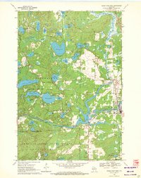
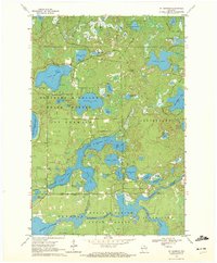
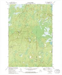
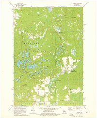
 1970 Julia Lake1972 Print · USGSOneida County's interconnected lake chains are captured here in the early seventies as the area grew into a recreational hub. Researchers can trace historic routes like Military Road and locate local landmarks such as Three Lakes Municipal Airport and Big Stone Lake.2 unique versions available
 - 1970 Map of Anvil Lake, 1972 Print
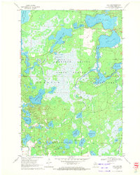
 1970 Anvil Lake1972 Print · USGSThe Nicolet National Forest at the start of the 1970s reveals a pristine landscape of glacial lakes and timber. Trace early recreation sites and forest infrastructure like the Anvil Lake Lookout Tower and Military Road.2 unique versions available
 - 1971 Map of Pier Lake, 1973 Print
 1971 Pier Lake1973 Print · USGSOneida County's western lakes and timberlands are captured here in the early seventies, showing a landscape shaped by the Willow Reservoir. Genealogists and local historians can trace the remote St Francis of Assisi Ch and old forest routes like Thunder Creek Road and Pier Lake Road.2 unique versions available
 - 1971 Map of Pike Lake SE, 1973 Print
 1971 Pike Lake SE1973 Print · USGSThe northern Wisconsin wilderness of Price and Oneida Counties is captured here in the early 1970s. Outdoor researchers and local historians can trace the headwaters of Foulds Creek and locate landmarks like the Lookout Tower and Steverson Spring.2 unique versions available
 - 1971 Map of Pike Lake, 1973 Print
 1971 Pike Lake1973 Print · USGSIn the early 1970s, the lake country at the junction of Price, Iron, and Vilas counties was a landscape of deep forests and interconnected waterways. Researchers can trace the Chippewa Trail, locate the Lookout Tower on Sentinel Point, and explore the shorelines of Round Lake and Pike Lake.
 - 1971 Map of Tripoli, 1973 Print
 1971 Tripoli1973 Print · USGSThe town of Tripoli and the surrounding woodlands come alive in this early 1970s survey of the Oneida and Lincoln county line. Researchers can trace the path of the SOO LINE railroad or locate local landmarks like the Wilson School and the shores of Somo Lake.
 - 1971 Map of Lac Du Flambeau, 1973 Print
 1971 Lac Du Flambeau1973 Print · USGSLac du Flambeau and its surrounding lakes are captured here in the early seventies, showing a landscape defined by water and forest. Researchers can trace the Reservation Boundary and find local landmarks like the Indian Agency and Strawberry Island.3 unique versions available
 - 1971 Map of Bradley, 1973 Print
 1971 Bradley1973 Print · USGSOneida and Lincoln Counties are captured here in the early seventies, a landscape shaped by the Little Rice River and the expanding Lake Nokomis flowage. Researchers can trace the Soo Line railroad through Bradley or locate the Prairie Rapids Cem amidst the northwoods lakeside drives.
 - 1971 Map of Burrows Lake, 1973 Print
 1971 Burrows Lake1973 Print · USGSOneida County's northwoods are captured in the early seventies, showing a landscape defined by the Willow Reservoir and the Tomahawk River. Researchers can trace old woods routes and locate landmarks like the Jack Pine Lookout Tower and the Cranberry Bog.2 unique versions available
 - 1971 Map of Lac Du Flambeau SW, 1973 Print
 1971 Lac Du Flambeau SW1973 Print · USGSOneida County's dense lake country is captured here in the early 1970s, showcasing a landscape of timber and wetlands before significant modern development. Researchers can trace historic access routes like Camp Nine Road and locate distinctive landmarks including the Squirrel Hill Lookout Tower and the sprawling Cranberry Bog.2 unique versions available
 - 1971 Map of Mercer Lake, 1973 Print
 1971 Mercer Lake1973 Print · USGSOneida County's lake-strewn wilderness is captured here in the early seventies, spanning the townships of Minocqua and Hazelhurst. Genealogists and historians can trace the course of the Tomahawk River and locate landmarks like Kitty Springs, Blue Lake, and the winding Manhardt Road.
 - 1971 Map of Fence Lake, 1973 Print
 1971 Fence Lake1973 Print · USGSThe Vilas County lake country is captured here in the early 1970s, during a time of significant recreational growth within the Lac du Flambeau Indian Reservation. Researchers can trace the Chicago and North Western rail line past Marlands or locate landmarks like the Flambeau Lookout Tower.
 - 1973 Map of Parrish, 1976 Print
 1973 Parrish1976 Print · USGSNorthern Wisconsin lake country in the 1970s is defined by its glacial terrain and timber history. Researchers can locate the Parrish Cem, trace the Old Railroad Grade, and explore the vast Prairie River State Public Hunting and Fishing Area.2 unique versions available
 - 1973 Map of Enterprise, 1976 Print
 1973 Enterprise1976 Print · USGSEnterprise and the surrounding lakelands are shown in the early 1970s, as the region's logging heritage transitioned toward conservation and recreation. Researchers can trace the path of the Old Railroad Grade and locate points of interest like the Lookout Tower and Payne Spring.
 - 1973 Map of Post Lake, 1977 Print
 1973 Post Lake1977 Print · USGSThe Wolf River corridor in the early 1970s reveals a landscape of interconnected lakes and protected fishery lands. Researchers can trace lakeside developments near Post Lake and locate specific features like Knoke Spring, Spider Creek Flowage, and the Wolf River State Fishery Area.2 unique versions available
 - 1973 Map of Elcho, 1977 Print
 1973 Elcho1977 Print · USGSUpper Langlade and Oneida counties are shown here in the early 1970s, as lakeside communities and rail-side junctions shaped the Northwoods. Trace family roots and local landmarks at St Johns Ch, Enterprise Cem, and the settlement of Elcho.
 - 1979 Map of Brantwood, 1980 Print
 1979 Brantwood1980 Print · USGSThe Northwoods landscape near the Price and Oneida county lines is captured here in the late seventies, centered on the Soo Line rail corridor. Genealogists and local historians can trace old homesteads and community sites like the Finnish Cem, Tripoli Sch, and the settlement of Brantwood.
End of results
Showing maps 1-23 of 23
Top cities of Oneida County
- Rhinelander historical maps
- Minocqua historical maps
- Newbold historical maps
- Three Lakes historical maps
- Sugar Camp historical maps
- Hazelhurst historical maps
See more
Frequently asked questions
- What are the different types of historical maps available for Oneida County?
- What is the oldest map of Oneida County?
- Where can I purchase historical maps of Oneida County for my home or office?
- Where can I download high-res historical maps of Oneida County?
- Are there historical topographic maps available for Oneida County?
- Is there historical aerial imagery available for Oneida County?
- Where are historical maps of Oneida County sourced from?