1940s Maps of Enterprise, Wisconsin
Explore 5 historic maps of Enterprise from the 1940s. These maps offer a rare glimpse into what life looked like during the 1940s — showing old roads, neighborhoods, homes, and landmarks that have changed or disappeared over time.
Whether you're researching your family's past, planning a metal detecting trip, or studying how Enterprise's landscape evolved across the 1940s, these high-resolution maps are a powerful tool for exploring the history of this region.
- Focus on a specific era: All maps on this page are from the 1940s, giving you a focused view of this time period.
- See what’s changed: Compare century-old streets, trails, and buildings to today's modern landscape using overlays and satellite layers.
- Research with precision: Use these maps for genealogy, historical research, land use analysis, or educational projects.
- View, download, or print: Maps are fully viewable online in high resolution, and can be downloaded or printed for your own records.
Start exploring Enterprise's history through authentic maps from the 1940s. This is your window into the past.
Enterprise, WI maps
(5)- 1940 Map of Parrish
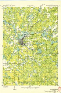
 1940 Parrish1940 Print · USGSUpper Wisconsin during the early 1940s is captured here at the edges of Three counties. Researchers can trace the Chicago and Northwestern rail line and locate the Enterprise settlement near Shingle Mill Lake before the full survey was completed.
 - 1940 Map of Monico, 1955 Print
 1940 Monico1955 Print · USGSThe Northwoods of Oneida and Forest counties are captured here just before the mid-century, defined by the crossing of major rail lines and a maze of glacial lakes. Genealogists and researchers can trace the early footprints of Monico, Jennings, and Nashville, or locate local landmarks like Forest Home Cem.
 - 1940 Map of Rhinelander, 1961 Print
 1940 Rhinelander1961 Print · USGSRhinelander and the surrounding lake country are captured here in the early 1940s, just as the rail-and-timber era had matured. Genealogists and local historians can trace rural school districts like Burkhart Sch and Clovernook Sch or locate the Our Saviour Ch among the region's many lakes.
 - 1942 Map of Elcho
 1942 Elcho1942 Print · USGSUpper Wisconsin’s lake country appears here in the early 1940s, showing a landscape of scattered rural schools and forest townships. Genealogists and researchers can trace local roots at the Enterprise Cem, St Johns Ch, or find family landmarks near Pelican Lake.
 - 1949 Map of Rhinelander
 1949 Rhinelander1949 Print · USGSNorthern Wisconsin lake country comes alive in this late 1940s survey centered on the bustling hub of Rhinelander. Genealogists and historians can trace the paths of the Chicago and North Western Railway or locate rural landmarks like Trotier Sch and Emden Sch.
End of results
Showing maps 1-5 of 5
Top cities near Enterprise
- Rhinelander historical maps
- Newbold historical maps
- Three Lakes historical maps
- Sugar Camp historical maps
- Elcho historical maps
- Neva historical maps
See more
Frequently asked questions
- What are the different types of historical maps available for Enterprise?
- What is the oldest map of Enterprise?
- Where can I purchase historical maps of Enterprise for my home or office?
- Where can I download high-res historical maps of Enterprise?
- Are there historical topographic maps available for Enterprise?
- Is there historical aerial imagery available for Enterprise?
- Where are historical maps of Enterprise sourced from?