1970s Maps of Couderay, Wisconsin
Explore 6 historic maps of Couderay from the 1970s. These maps offer a rare glimpse into what life looked like during the 1970s — showing old roads, neighborhoods, homes, and landmarks that have changed or disappeared over time.
Whether you're researching your family's past, planning a metal detecting trip, or studying how Couderay's landscape evolved across the 1970s, these high-resolution maps are a powerful tool for exploring the history of this region.
- Focus on a specific era: All maps on this page are from the 1970s, giving you a focused view of this time period.
- See what’s changed: Compare century-old streets, trails, and buildings to today's modern landscape using overlays and satellite layers.
- Research with precision: Use these maps for genealogy, historical research, land use analysis, or educational projects.
- View, download, or print: Maps are fully viewable online in high resolution, and can be downloaded or printed for your own records.
Start exploring Couderay's history through authentic maps from the 1970s. This is your window into the past.
Couderay, WI maps
(6)- 1971 Map of Couderay, 1973 Print
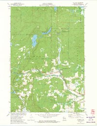 1971 Couderay1973 Print · USGSSawyer County’s river-fed lowlands and protected wildlands are captured here in the early seventies. Local historians and genealogists can trace the early layout of Couderay and Lemington, or locate landmarks like the Cemetery and the Tuscobia-Park Falls State Trail.2 unique versions available
 - 1971 Map of Chief Lake, 1973 Print
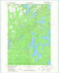 1971 Chief Lake1973 Print · USGSSawyer County’s glacial lake country is captured here in the early 1970s, showcasing the intersection of tribal lands and Northwoods recreation. Genealogists and local historians can locate the Round Lake Cem and trace old routes like Trepania Road and Gurno Road.
 - 1971 Map of Hauer, 1973 Print
 1971 Hauer1973 Print · USGSSawyer County’s lake-country landscape is documented here in the early 1970s, as traditional rail corridors began their transition to conservation trails. Researchers can locate the Wayside Chapel, trace the Soo Line railroad, and explore the vast Billy Boy Flowage.
 - 1971 Map of Reserve, 1974 Print
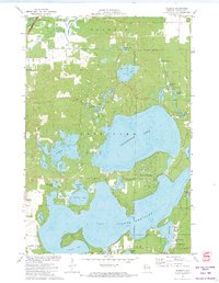 1971 Reserve1974 Print · USGSThe Northwoods of Sawyer County come to life in the early seventies, centered on the historic settlement of Reserve. Genealogists and historians can locate rural landmarks like St Francis Solanus Mission and the shoreline cottages of Northwoods Beach.2 unique versions available
 - 1972 Map of Edgewater, 1975 Print
 1972 Edgewater1975 Print · USGSSawyer County at the start of the 1970s shows a landscape of deep-water bays and northwoods trails. Genealogists and historians can trace the Old Railroad Grade past Yarnell or locate family sites near Edgewater and Wooddale.
 - 1972 Map of Weirgor, 1975 Print
 1972 Weirgor1975 Print · USGSSawyer and Rusk Counties are captured in the early seventies, showing a landscape shaped by the Soo Line and the Meteor Hills. Researchers can trace old foundations near Meteor or explore the Weirgor Springs State Wildlife Area.
End of results
Showing maps 1-6 of 6
Top cities near Couderay
- Hayward historical maps
- Edgewater historical maps
- Birchwood historical maps
- Weirgor historical maps
- Ojibwa historical maps
- Murry historical maps
See more
Top neighborhoods of Couderay
Frequently asked questions
- What are the different types of historical maps available for Couderay?
- What is the oldest map of Couderay?
- Where can I purchase historical maps of Couderay for my home or office?
- Where can I download high-res historical maps of Couderay?
- Are there historical topographic maps available for Couderay?
- Is there historical aerial imagery available for Couderay?
- Where are historical maps of Couderay sourced from?