1890s Maps of Waukesha County, Wisconsin
Explore 10 historic maps of Waukesha County from the 1890s. These maps offer a rare glimpse into what life looked like during the 1890s — showing old roads, neighborhoods, homes, and landmarks that have changed or disappeared over time.
Whether you're researching your family's past, planning a metal detecting trip, or studying how Waukesha County's landscape evolved across the 1890s, these high-resolution maps are a powerful tool for exploring the history of this region.
- Focus on a specific era: All maps on this page are from the 1890s, giving you a focused view of this time period.
- See what’s changed: Compare century-old streets, trails, and buildings to today's modern landscape using overlays and satellite layers.
- Research with precision: Use these maps for genealogy, historical research, land use analysis, or educational projects.
- View, download, or print: Maps are fully viewable online in high resolution, and can be downloaded or printed for your own records.
Start exploring Waukesha County's history through authentic maps from the 1890s. This is your window into the past.
Waukesha County, WI maps
(10)- 1891 Map of Muskego, 1896 Print
 1891 Muskego1896 Print · USGSSoutheast Wisconsin in the early 1890s was a landscape of expansive lake systems and rural townships connected by early rail and river routes. Genealogists can trace family holdings and vanished crossroads like Big Bend, Prospect Hill, and Denoon.
 - 1892 Map of Waukesha
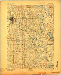
 1892 Waukesha1892 Print · USGSSoutheast Wisconsin in the 1890s was a critical junction of rail lines and river valleys connecting small industrial settlements. Trace the early development of Waukesha and Wauwatosa before suburban expansion, or locate vanished stops like Templeton and Brookfield Junction.
 - 1892 Map of Watertown
 1892 Watertown1892 Print · USGSJefferson and Dodge counties at the close of the nineteenth century are defined by their winding river valleys and newly established rail corridors. Genealogists can trace family roots in early settlements like Watertown, Ixonia, and Sullivan, or follow the Rock River to its junction with the Oconomowoc River.
 - 1892 Map of Oconomowoc
 1892 Oconomowoc1892 Print · USGSWaukesha County's lake country is captured in the early 1890s, revealing a landscape defined by glacial waters and nascent rail lines. Researchers can trace the early development of Delafield and Hartland or locate old stops like Lakeside Station and Giffords.4 unique versions available
 - 1892 Map of Whitewater
 1892 Whitewater1892 Print · USGSSoutheastern Wisconsin's glaciated landscape is revealed in the late nineteenth century as the rail network began to shape local growth. Trace the path of the Chicago Milwaukee And St. Paul Railroad through Whitewater, Palmyra, and the marshes of the Bark River.
 - 1892 Map of Eagle
 1892 Eagle1892 Print · USGSSoutheast Wisconsin's glaciated landscape is captured here in the late nineteenth century as new rail lines transformed the frontier into a network of dairy and mill towns. Genealogists can trace early homesteads and rail stops like Genesee Depot, Caldwell Prairie, and Eagleville near the shores of Phantom Lake.
 - 1893 Map of Whitewater
 1893 Whitewater1893 Print · USGSThe dairy lands and glacial lake districts of southeastern Wisconsin are captured here in the late nineteenth century. Trace the early village footprints of Whitewater and Palmyra, or follow the iron path of the Prairie Du Chien Division Railroad past Lauderdale Lakes.7 unique versions available
 - 1894 Map of Watertown
 1894 Watertown1894 Print · USGSSouthern Wisconsin at the close of the nineteenth century reveals a landscape shaped by glacial ridges and the iron horse. Genealogists can trace family footprints in settlements like Watertown, Ixonia, and Sullivan, or follow the rail lines that connected Lac La Belle to the wider region.5 unique versions available
 - 1894 Map of Eagle
 1894 Eagle1894 Print · USGSSoutheast Wisconsin in the late nineteenth century was defined by a thriving rail network and glacial lake landscapes. Researchers can trace the early footprints of settlements like Genesee and East Troy alongside the Fox River and the Wisconsin Central Railroad.
 - 1897 Map of Eagle
 1897 Eagle1897 Print · USGSSoutheast Wisconsin in the late nineteenth century was a landscape of thriving rail-side villages and interconnected kettle lakes. Genealogists and researchers can trace early homesteads and rail stops like Genesee Depot, North Prairie, and the bustling lakefront at Mukwonago.
End of results
Showing maps 1-10 of 10
Top cities of Waukesha County
- Waukesha historical maps
- Brookfield historical maps
- New Berlin historical maps
- Menomonee Falls historical maps
- Muskego historical maps
- Oconomowoc historical maps
See more
Frequently asked questions
- What are the different types of historical maps available for Waukesha County?
- What is the oldest map of Waukesha County?
- Where can I purchase historical maps of Waukesha County for my home or office?
- Where can I download high-res historical maps of Waukesha County?
- Are there historical topographic maps available for Waukesha County?
- Is there historical aerial imagery available for Waukesha County?
- Where are historical maps of Waukesha County sourced from?