1990s Maps of Waupaca County, Wisconsin
Explore 9 historic maps of Waupaca County from the 1990s. These maps offer a rare glimpse into what life looked like during the 1990s — showing old roads, neighborhoods, homes, and landmarks that have changed or disappeared over time.
Whether you're researching your family's past, planning a metal detecting trip, or studying how Waupaca County's landscape evolved across the 1990s, these high-resolution maps are a powerful tool for exploring the history of this region.
- Focus on a specific era: All maps on this page are from the 1990s, giving you a focused view of this time period.
- See what’s changed: Compare century-old streets, trails, and buildings to today's modern landscape using overlays and satellite layers.
- Research with precision: Use these maps for genealogy, historical research, land use analysis, or educational projects.
- View, download, or print: Maps are fully viewable online in high resolution, and can be downloaded or printed for your own records.
Start exploring Waupaca County's history through authentic maps from the 1990s. This is your window into the past.
Waupaca County, WI maps
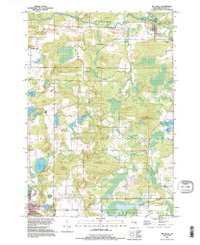
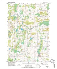
(9)- 1992 Map of Waupaca, 1995 Print
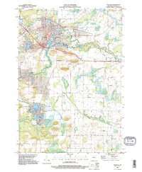 1992 Waupaca1995 Print · USGSWaupaca and its surrounding glacial lake country are captured here during the early nineties, showing the city's relationship with the local river systems. Researchers can trace family roots at Lakeside Cem or locate old community centers like Little Hope and Lind Center.
 - 1992 Map of Ogdensburg, 1995 Print
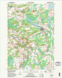 1992 Ogdensburg1995 Print · USGSCentral Wisconsin at the dawn of the nineties shows a landscape of glacial lakes and quiet river valleys. Genealogists can trace family footprints near Ogdensburg via Iola Cem, Ogdensburg Cem, and the timbered slopes of Poverty Hill.
 - 1992 Map of New London, 1995 Print
 1992 New London1995 Print · USGSThe riverfront city of New London and the nearby settlement of Sugar Bush are captured here as they appeared in the early nineties. Genealogists and local historians can trace family-named sites like Ruckdashel Cem and landmarks such as Mosquito Hill.
 - 1992 Map of Leeman, 1996 Print
 1992 Leeman1996 Print · USGSIn the 1990s, the Wolf River basin in Outagamie County remained a vast wetland corridor preserved through state wildlife areas. Researchers can trace rural lineages at St Lawrence Cem and Oak Hill Cem or locate the riverside hamlet of Leeman.
 - 1992 Map of Big Falls, 1996 Print
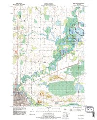
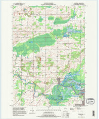
 1992 Big Falls1996 Print · USGSWaupaca County in the 1990s reveals a landscape of glacial lakes and river-borne history. Researchers can trace the Old RR Grade through Big Falls or locate family landmarks near Schmidt Corner and Goodhal Lake.
 - 1993 Map of Northport, 1995 Print
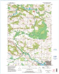
 1993 Northport1995 Print · USGSWaupaca County's river valleys and wetlands are captured in the mid-1990s as the Wolf River winds through the countryside. Researchers can trace local lineage through sites like St Patrick Cem, the settlement at Fitzgerald Corners, and family land along Nicolai Road.
 - 1993 Map of Clintonville South, 1995 Print
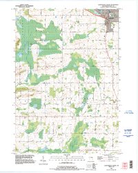 1993 Clintonville South1995 Print · USGSClintonville and its southern rural townships are captured in the early nineties, showing a landscape defined by traditional rail corridors and meandering river systems. Genealogists can locate family-named landmarks and several historic burial sites, including Graceland Cem and Townline Cem, while tracing the course of Bear Creek.
 - 1993 Map of Clintonville North, 1995 Print
 1993 Clintonville North1995 Print · USGSThe border of Shawano and Waupaca counties comes alive in the early 1990s as the river-fed landscape of Pella and Clintonville is documented. Genealogists can locate family landmarks like the St Martin Cem or trace rural routes like Magolski Road and Nietzke Road.
 - 1993 Map of Symco, 1996 Print
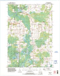
 1993 Symco1996 Print · USGSWaupaca County's rural townships are detailed here in the 1990s as a landscape of interconnected kettle lakes and winding river valleys. Researchers can trace family-named roads and locate historical landmarks like the Danish Cem, Symco, and School Section Lake.
End of results
Showing maps 1-9 of 9
Top cities of Waupaca County
- Waupaca historical maps
- Clintonville historical maps
- Weyauwega historical maps
- Manawa historical maps
- Marion historical maps
- Iola historical maps
See more
Frequently asked questions
- What are the different types of historical maps available for Waupaca County?
- What is the oldest map of Waupaca County?
- Where can I purchase historical maps of Waupaca County for my home or office?
- Where can I download high-res historical maps of Waupaca County?
- Are there historical topographic maps available for Waupaca County?
- Is there historical aerial imagery available for Waupaca County?
- Where are historical maps of Waupaca County sourced from?