1890s Maps of Big Horn County, Wyoming
Explore 4 historic maps of Big Horn County from the 1890s. These maps offer a rare glimpse into what life looked like during the 1890s — showing old roads, neighborhoods, homes, and landmarks that have changed or disappeared over time.
Whether you're researching your family's past, planning a metal detecting trip, or studying how Big Horn County's landscape evolved across the 1890s, these high-resolution maps are a powerful tool for exploring the history of this region.
- Focus on a specific era: All maps on this page are from the 1890s, giving you a focused view of this time period.
- See what’s changed: Compare century-old streets, trails, and buildings to today's modern landscape using overlays and satellite layers.
- Research with precision: Use these maps for genealogy, historical research, land use analysis, or educational projects.
- View, download, or print: Maps are fully viewable online in high resolution, and can be downloaded or printed for your own records.
Start exploring Big Horn County's history through authentic maps from the 1890s. This is your window into the past.
Big Horn County, WY maps
(4)- 1894 Map of St. Xavier
 1894 St. Xavier1894 Print · USGSThe Crow Indian Reservation in the 1890s is captured here just as the frontier era was closing. Researchers can trace the path of the Old Bozeman Military Road past St. Xavier Mission and the Site of Old Fort C. F. Smith.
 - 1895 Map of Dayton
 1895 Dayton1895 Print · USGSSheridan County and the Bighorn foothills are captured here in the late nineteenth century as ranching and transit began to define the region. Genealogists and researchers can trace the early road networks connecting Dayton, Ohlman, and the ranching hub at Beckton.
 - 1898 Map of Bald Mountain, 1957 Print
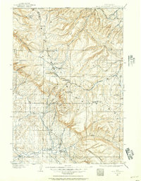 1898 Bald Mountain1957 Print · USGSThe northern Bighorn Mountains appear in the 1890s as a frontier of high-altitude ranching and mining. Trace the early trails leading to the Fortunatus Mill, remote landmarks like Sheldons Ranch, and the isolated settlement of Cloverly.2 unique versions available
 - 1899 Map of Cloud peak, 1960 Print
 1899 Cloud peak1960 Print · USGSThe high wilderness of the Big Horn Mountains is captured here at the end of the century, showing the remote crest and early county boundaries. Hikers and historians can trace the paths to Lake Helen, the outposts at Soldier Park, and the heights of Cloud Pk.
End of results
Showing maps 1-4 of 4
Top cities of Big Horn County
- Lovell historical maps
- Greybull historical maps
- Basin historical maps
- Cowley historical maps
- Byron historical maps
- Burlington historical maps
See more
Frequently asked questions
- What are the different types of historical maps available for Big Horn County?
- What is the oldest map of Big Horn County?
- Where can I purchase historical maps of Big Horn County for my home or office?
- Where can I download high-res historical maps of Big Horn County?
- Are there historical topographic maps available for Big Horn County?
- Is there historical aerial imagery available for Big Horn County?
- Where are historical maps of Big Horn County sourced from?