Old Maps of Rawlins, Wyoming for Academic Research
Study the evolution of Rawlins with 11 high-resolution historic maps. Whether you're teaching, researching, or modeling changes in land use, these maps provide essential visual documentation of urban, environmental, and geographic change.
- Analyze long-term change: Track patterns in development, transportation, and natural features.
- Ideal for environmental or urban studies: Support academic projects with primary historical map data.
- Use in the classroom or lab: Educators and researchers rely on these maps to bring historical context to life.
These maps are a powerful tool for teaching, research, and visualizing how Rawlins has changed over the decades.
Rawlins, WY maps
(11)- 1953 Map of Rawlins, 1955 Print
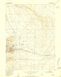 1953 Rawlins1955 Print · USGSRawlins is shown as a critical transportation and institutional hub in the 1950s, defined by the meeting of rail and road. Researchers can trace the layout of the State Penitentiary and the grounds of the Rawlins Airport or Rawlins Cemetery.4 unique versions available
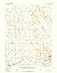
 - 1954 Map of Rawlins, 1968 Print
 1954 Rawlins1968 Print · USGSThe high plains and mountain ranges of southern Wyoming are shown here in the mid-1950s as the Union Pacific railroad and early highways fueled local industry. Genealogists and historians can trace old homesteads and outposts like the Overland Stage Station, the Utah Oil Refining Station, and the Hadsell Winter Headquarters.2 unique versions available
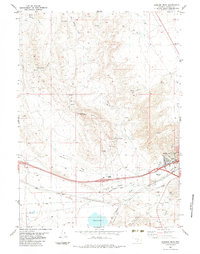
 - 1956 Map of Rawlins Peak, 1959 Print
 1956 Rawlins Peak1959 Print · USGSCarbon County ranching and transit corridors are captured here in the mid-1950s, showing the intersection of high-desert life and major western arteries. Genealogists and historians can trace family operations at Mahoney Ranch or follow the path of the original Lincoln Highway and Union Pacific railroad.
 - 1958 Map of Rawlins
 1958 Rawlins1958 Print · USGSSouthern Wyoming at the mid-century shows a landscape defined by the Union Pacific Railroad and the high basins of the Continental Divide. Researchers can trace old transportation routes near Fort Fred Steele or explore the mining history around Hanna and Medicine Bow.2 unique versions available
 - 1962 Map of Rawlins
 1962 Rawlins1962 Print · USGSSouthern Wyoming at the dawn of the sixties shows a landscape shaped by the Union Pacific and the high peaks of the Medicine Bow Mountains. Researchers can trace the path of the old stage routes through Overland Stage Station and Fort Fred Steele.
 - 1967 Map of Rawlins
 1967 Rawlins1967 Print · USGSCentral Wyoming and northern Colorado in the 1980s are defined here by the Union Pacific corridor and the high peaks of the Sierra Madre. Researchers can trace the legacy of old mining and rail towns like Carbon, Hanna, and Medicine Bow along the Overland Trail.
 - 1983 Map of Rawlins Peak
 1983 Rawlins Peak1983 Print · USGSThe high Wyoming basin at the foot of the mountains comes into focus during the early eighties, centered on the railroad hub of Rawlins. Researchers can trace the path of the Union Pacific, locate the Radio Tower (KRAL), and explore the rugged drainage of Sixteenmile Draw.
 - 1984 Map of Rawlins
 1984 Rawlins1984 Print · USGSRawlins and the high-desert basins of Carbon County are shown in the mid-1980s as a vital transportation and energy corridor. Researchers can trace the historic Overland Trail and locate coal operations like Cherokee Mine No. 1 and the State Penitentiary.
 - 1988 Map of Rawlins
 1988 Rawlins1988 Print · USGSSouthern Wyoming and the Colorado borderlands are detailed here in the late eighties, featuring the intersection of the historic Overland Trail and the Union Pacific. Researchers can trace old rail towns like Medicine Bow and Wamsutter or landmark peaks like Medicine Bow Peak.
 - 2021 Map of Rawlins, 2021 Print
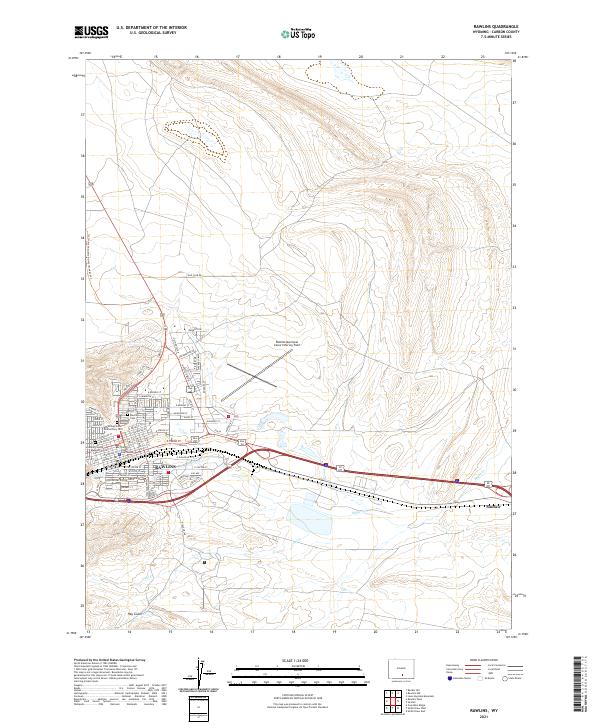 2021 Rawlins2021 Print · USGSRawlins and Sinclair sit at the crossroads of the Continental Divide and the transcontinental rail corridor in the early twenty-first century. Genealogists and researchers can trace local roots at the Rawlins Cem, the Wyoming State Penitentiary Cem, and the Carbon County Courthouse.
 - 2021 Map of Rawlins Peak, 2021 Print
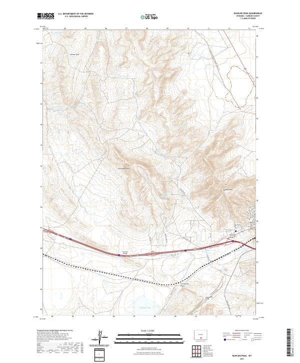 2021 Rawlins Peak2021 Print · USGSCarbon County’s high-elevation terrain is captured here in the early twenty-first century, showing the intersection of recreation and interstate transit. Trace the Continental Divide National Scenic Trail past Rawlins Peak or locate water at Indian Spring and Hogback Lake.
End of results
Showing maps 1-11 of 11
Top cities near Rawlins
Frequently asked questions
- What are the different types of historical maps available for Rawlins?
- What is the oldest map of Rawlins?
- Where can I purchase historical maps of Rawlins for my home or office?
- Where can I download high-res historical maps of Rawlins?
- Are there historical topographic maps available for Rawlins?
- Is there historical aerial imagery available for Rawlins?
- Where are historical maps of Rawlins sourced from?