Old Maps of Torrington, Wyoming for Hiking & Exploration
Hike through history with 10 historic maps of Torrington. Explore old trails, ghost towns, and forgotten backroads — perfect for outdoor adventurers and local explorers.
- Rediscover forgotten places: Map out old mining camps, roads, and footpaths that no longer exist on modern maps.
- Layer with modern tools: Combine with LiDAR or satellite views to plan hikes through historical terrain.
- Made for exploration: Popular among hikers, overlanders, and local history lovers.
Use these maps to find adventure and explore the hidden past of Torrington.
Torrington, WY maps
(10)- 1896 Map of Patrick
 1896 Patrick1896 Print · USGSEastern Wyoming ranching life is frozen in time during the mid-1890s, when family-run operations dominated the high plains. Genealogists can trace early homesteads like Nolan's Ranch, Sturdivant's Ranch, and the early settlement at Torrington.7 unique versions available
 - 1954 Map of Torrington, 1963 Print
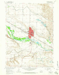
 1954 Torrington1963 Print · USGSEastern Wyoming and the Nebraska borderlands are captured here during the mid-fifties, showing a landscape shaped by the Platte River and the Laramie Range. Researchers can trace deep history at the Fort Laramie National Historical Site, the Old Doty Ranch Site, and along the Old Fetterman Road.4 unique versions available
 - 1958 Map of Torrington
 1958 Torrington1958 Print · USGSEastern Wyoming and the Nebraska borderlands are captured in the late fifties, showcasing a landscape of high plains ranching and river-fed industry. Trace the historic paths of the Union Pacific railroad and find legacy sites like Fort Laramie and Sunrise.
 - 1963 Map of Torrington SE, 1965 Print
 1963 Torrington SE1965 Print · USGSThe high plains of the Wyoming-Nebraska border are captured here in the early 1960s, showing the intersection of pioneer history and modern irrigation. Researchers can trace the path of the Emigrant Trail near the North Platte River and locate local sites like Hunton Meadows and Henry.
 - 1963 Map of Torrington, 1965 Print
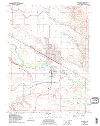
 1963 Torrington1965 Print · USGSTorrington and the North Platte River valley are shown in the early sixties, a landscape where historical overland routes meet mid-century irrigation and rail. Researchers can trace the Emigrant and North Platte Trail alongside the Chicago Burlington and Quincy railroad and landmarks like St Josephs Orphanage.2 unique versions available
 - 1978 Map of Torrington
 1978 Torrington1978 Print · USGSSoutheast Wyoming in the late seventies reveals a landscape shaped by the North Platte River and a dense network of major rail lines. Researchers can locate the Fort Laramie National Historic Site, the Camp Guernsey Training Area, and original stops along the Union Pacific railroad.2 unique versions available
 - 1990 Map of Torrington, 1995 Print
 1990 Torrington1995 Print · USGSTorrington and the North Platte River valley are shown in the 1990s as a landscape shaped by irrigation and western migration history. Genealogists and local historians can trace the Emigrant Trail, locate graves at Valley View Cemetery, and explore the layout of South Torrington.
 - 1990 Map of Torrington SE, 1995 Print
 1990 Torrington SE1995 Print · USGSThe Wyoming and Nebraska borderlands come alive in the 1990s as the North Platte River meets a legacy of westward migration. Trace the historic Emigrant Trail near Hunton Meadows and explore the vast irrigation network of the Interstate Canal.
 - 2021 Map of Torrington SE, 2021 Print
 2021 Torrington SE2021 Print · USGSThe high plains at the Wyoming and Nebraska border are revealed in this study of the irrigation and ranching networks near Torrington. Trace the intricate path of the North Platte River and the engineered waterways of the Interstate Canal and Lateral Number 1.
 - 2021 Map of Torrington, 2021 Print
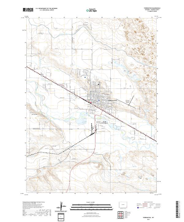 2021 Torrington2021 Print · USGSTorrington and the North Platte River valley are documented here in 2021, showing the area's vital irrigation and rail infrastructure. Researchers can trace the BNSF Railway corridor through Torrington and locate landmarks like Valley View Cem and the Goshen County Courthouse.
End of results
Showing maps 1-10 of 10
Top cities near Torrington
- Morrill historical maps
- Lingle historical maps
- Lyman historical maps
- Yoder historical maps
- Henry historical maps
Frequently asked questions
- What are the different types of historical maps available for Torrington?
- What is the oldest map of Torrington?
- Where can I purchase historical maps of Torrington for my home or office?
- Where can I download high-res historical maps of Torrington?
- Are there historical topographic maps available for Torrington?
- Is there historical aerial imagery available for Torrington?
- Where are historical maps of Torrington sourced from?