1910s Maps of Hot Springs County, Wyoming
Explore 6 historic maps of Hot Springs County from the 1910s. These maps offer a rare glimpse into what life looked like during the 1910s — showing old roads, neighborhoods, homes, and landmarks that have changed or disappeared over time.
Whether you're researching your family's past, planning a metal detecting trip, or studying how Hot Springs County's landscape evolved across the 1910s, these high-resolution maps are a powerful tool for exploring the history of this region.
- Focus on a specific era: All maps on this page are from the 1910s, giving you a focused view of this time period.
- See what’s changed: Compare century-old streets, trails, and buildings to today's modern landscape using overlays and satellite layers.
- Research with precision: Use these maps for genealogy, historical research, land use analysis, or educational projects.
- View, download, or print: Maps are fully viewable online in high resolution, and can be downloaded or printed for your own records.
Start exploring Hot Springs County's history through authentic maps from the 1910s. This is your window into the past.
Hot Springs County, WY maps
(6)- 1911 Map of Meeteetse, 1957 Print
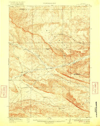
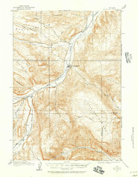 1911 Meeteetse1957 Print · USGSMeeteetse and the Bighorn Basin are captured here in the early twentieth century as ranching and early mining took hold. Researchers can trace the historic Cody Road and locate old landmarks like the Black Diamond Mine and Renner's Ranch.
 - 1913 Map of Meeteetse
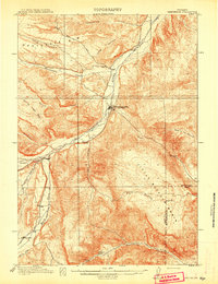 1913 Meeteetse1913 Print · USGSMeeteetse and the surrounding ranchlands are captured here in the years before World War I. Researchers can trace the early road network like Cody Road or locate historical sites such as Dumbell, Sunshine, and the Black Diamond Mine.3 unique versions available
 - 1913 Map of Grass Creek Basin, 1962 Print
 1913 Grass Creek Basin1962 Print · USGSHot Springs County ranching life is preserved here during the early twentieth century, showing a remote landscape of isolated family homesteads and vital water sources. Genealogists and historians can locate early properties like Wales Ranch and Kemp Ranch, or trace the rugged geography of the Putney Mine and Grass Creek Basin.2 unique versions available
 - 1914 Map of Blue Mesa, 1975 Print
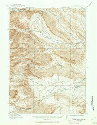
 1914 Blue Mesa1975 Print · USGSHot Springs and Washakie Counties are documented here shortly after the turn of the century, showing a remote landscape defined by its vital water sources. Researchers can trace the paths of Cottonwood Creek and Grass Creek, or locate Keg Spring and Harris Spring among the draws of Blue Mesa.
 - 1915 Map of Grass Creek Basin
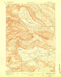 1915 Grass Creek Basin1915 Print · USGSHot Springs County homesteads and early Wyoming resource extraction are documented here in the years before the Great War. Genealogists and historians can locate family-named landmarks like Littlejohn Ranch, Putney Mine, and Wagonhound Spring.3 unique versions available
 - 1916 Map of Blue Mesa
 1916 Blue Mesa1916 Print · USGSHot Springs and Washakie counties are captured here just before the Great War, showing a network of high-desert drainages and cattle country. Trace early water sources like Harris Spring, Ivy Spring, and the winding Grass Creek through the Blue Mesa landscape.2 unique versions available
End of results
Showing maps 1-6 of 6
Top cities of Hot Springs County
Frequently asked questions
- What are the different types of historical maps available for Hot Springs County?
- What is the oldest map of Hot Springs County?
- Where can I purchase historical maps of Hot Springs County for my home or office?
- Where can I download high-res historical maps of Hot Springs County?
- Are there historical topographic maps available for Hot Springs County?
- Is there historical aerial imagery available for Hot Springs County?
- Where are historical maps of Hot Springs County sourced from?