1980s Maps of Hot Springs County, Wyoming
Explore 14 historic maps of Hot Springs County from the 1980s. These maps offer a rare glimpse into what life looked like during the 1980s — showing old roads, neighborhoods, homes, and landmarks that have changed or disappeared over time.
Whether you're researching your family's past, planning a metal detecting trip, or studying how Hot Springs County's landscape evolved across the 1980s, these high-resolution maps are a powerful tool for exploring the history of this region.
- Focus on a specific era: All maps on this page are from the 1980s, giving you a focused view of this time period.
- See what’s changed: Compare century-old streets, trails, and buildings to today's modern landscape using overlays and satellite layers.
- Research with precision: Use these maps for genealogy, historical research, land use analysis, or educational projects.
- View, download, or print: Maps are fully viewable online in high resolution, and can be downloaded or printed for your own records.
Start exploring Hot Springs County's history through authentic maps from the 1980s. This is your window into the past.
Hot Springs County, WY maps
(14)- 1981 Map of Thermopolis, 1982 Print
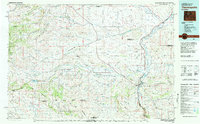 1981 Thermopolis1982 Print · USGSCentral Wyoming in the early eighties shows a landscape of geothermal wonders and energy extraction. Trace the legacy of early settlements and industry near Hot Springs State Park, the rail lines of the Burlington Northern, and outposts like Gebo and Hamilton Dome.
 - 1982 Map of Lysite
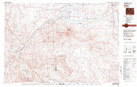
 1982 Lysite1982 Print · USGSCentral Wyoming's high plains and mountain foothills are captured here in the early 1980s, centered on the ranching and rail outposts of Natrona and Fremont Counties. Genealogists and historians can trace the paths of the Burlington Northern and the Old Railroad Grade through Lysite, Lost Cabin, and Arminto.
 - 1982 Map of Basin, 1983 Print
 1982 Basin1983 Print · USGSBig Horn and Park counties in the early eighties were defined by the high-desert benches and the vital waters of the Bighorn River. Researchers can trace the rail-and-river economy through the Burlington Northern line and locate local landmarks like the Eagle Mine or the Bird Reservation at Loch-Katrine.
 - 1985 Map of Hamilton Dome
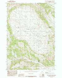
 1985 Hamilton Dome1985 Print · USGSThe energy frontier of central Wyoming comes into focus in the mid-1980s, centered on the Hamilton Dome oil operations. Researchers can trace extraction infrastructure across the Wind River Indian Reservation and locate local landmarks like Lake Charlie.
 - 1985 Map of Cedar Mountain
 1985 Cedar Mountain1985 Print · USGSHot Springs and Washakie counties meet in this mid-1980s landscape defined by the high prominence of Cedar Mountain. Researchers can trace the network of ephemeral watercourses and early water management features like Mc Cee Reservoir and Sand Draw.
 - 1985 Map of Little Buffalo Basin
 1985 Little Buffalo Basin1985 Print · USGSThe Little Buffalo Basin and the Park-Hot Springs county line are shown in the mid-1980s as the regional energy industry flourished. Local researchers can locate the Little Buffalo Basin Camp, an Oil Field, and a remote Landing Strip.
 - 1985 Map of Grass Creek
 1985 Grass Creek1985 Print · USGSIn the mid-1980s, this pocket of Hot Springs County was a hub of energy production centered on the Grass Creek settlement. Researchers can trace the extensive footprint of the Grass Creek Oil Field and Grass Creek Gas Field amidst landmarks like Enos and Sand Draw.
 - 1985 Map of Crater Sink
 1985 Crater Sink1985 Print · USGSHot Springs, Wyoming, is captured here in the mid-1980s, revealing a landscape of high benches and crucial water sources. Researchers can trace the drainages of Wagonhound Creek and Cottonwood Creek, or locate landmarks like Crater Sink and Wagonhound Spring.
 - 1985 Map of Blue Mesa West
 1985 Blue Mesa West1985 Print · USGSThe high plains of Wyoming are captured in the mid-1980s as they span the Hot Springs and Washakie county lines. Researchers can trace the rugged drainage patterns of Gooseberry Creek, find the landmark of Rankin, and follow the long spine of Blue Mesa Ridge.
 - 1985 Map of Little Sand Draw
 1985 Little Sand Draw1985 Print · USGSThe high plains of the Bighorn Basin are captured here in the mid-1980s, revealing the complex drainage systems of Hot Springs and Washakie counties. Researchers can trace the winding paths of Little Sand Draw, locate Harris Spring, and follow the historic Lower Wagon Gulch.
 - 1985 Map of Gloin Reservoir
 1985 Gloin Reservoir1985 Print · USGSHot Springs County in the late seventies and early eighties is defined by its drainage basins and energy potential. Researchers can trace the layout of Gloin Reservoir, locate mining Prospects, and follow the winding path of Wagon Gulch.
 - 1985 Map of Kirby
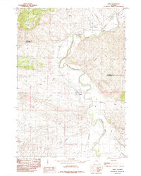 1985 Kirby1985 Print · USGSThe Bighorn River valley in the mid-1980s reveals a landscape shaped by irrigation and early industry. Trace the reach of the Hanover Canal and explore the historic settlements of Gebo and Kirby as they appeared forty years ago.
 - 1985 Map of Red Ridge
 1985 Red Ridge1985 Print · USGSThe high basins and ridges of Hot Springs County are captured here in the mid-1980s, during a period of steady natural resource exploration. Geologists and local historians can trace the paths of Coalmine Gulch and Kester Coulee through the complex elevations of Red Ridge.
 - 1985 Map of Blue Mesa East
 1985 Blue Mesa East1985 Print · USGSWashakie and Hot Springs counties are captured in the mid-eighties as a high-altitude landscape defined by ridges and deep gulches. Researchers can trace the rugged topography of Boulder Ridge and identify vital water sources like Keg Spring and Gooseberry Creek.
End of results
Showing maps 1-14 of 14
Top cities of Hot Springs County
Frequently asked questions
- What are the different types of historical maps available for Hot Springs County?
- What is the oldest map of Hot Springs County?
- Where can I purchase historical maps of Hot Springs County for my home or office?
- Where can I download high-res historical maps of Hot Springs County?
- Are there historical topographic maps available for Hot Springs County?
- Is there historical aerial imagery available for Hot Springs County?
- Where are historical maps of Hot Springs County sourced from?