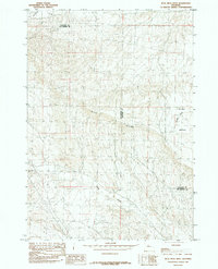
1985 Map of Blue Mesa West
USGS Topo · Published 1985About this map
Blue Mesa Ridge dominates this mid-1980s landscape, serving as a significant geographical divider along the border of Hot Springs and Washakie counties. The terrain is characterized by dissected highlands and drainage systems where water and geography dictate the movement through the region. Seasonal and perennial water sources like Gooseberry Creek in the north and Grass Creek in the south carve paths through the elevated plains, while Spring Gulch cuts into the eastern slopes. A localized high point at Rankin offers a specific landmark within this expansive rangeland. The map illustrates a period before significant modern development, focusing on the natural topography and the sparse infrastructure typical of the Wyoming interior, where county lines follow the natural rises and falls of the high desert environment.
Find a feature on this map
7 named features on this map. Tap any name to fly to it.
Don’t see what you’re looking for? This feature index may not catch every label — zoom into the map to look around manually.
Map Details
Editions of this 1985 Blue Mesa West Map
This is the sole edition of this map. No revisions or reprints were ever made.
Other maps of this area

1913 · Grass Creek Basin
USGS Topo · 1:62,500

1914 · Blue Mesa
USGS Topo · 1:62,500

1915 · Grass Creek Basin
USGS Topo · 1:62,500

1916 · Blue Mesa
USGS Topo · 1:62,500

1951 · Dutch Nick Flat
USGS Topo · 1:24,000

1951 · Dutch Nick Flat SW
USGS Topo · 1:24,000

1951 · Gillies Draw
USGS Topo · 1:24,000

1955 · Cody
USGS Topo · 1:250,000

1955 · Thermopolis
USGS Topo · 1:250,000

1958 · Cody
USGS Topo · 1:250,000