Old Maps of Hawkeye, Wyoming
Explore 10 old maps of Hawkeye, spanning from 1893 to today. These high-resolution historic maps reveal how streets, neighborhoods, landmarks, and natural features evolved over time — perfect for genealogy, metal detecting, research, and local history exploration.
What you can do with these maps:
- See how Hawkeye changed over time: Compare historical maps to modern-day views to trace roads, homesites, rail lines & more.
- View detailed metadata: Each map includes creators, publishers, year, scale, and archive source.
- Overlay maps with satellite & LiDAR: Visualize the past alongside modern tools to explore terrain & human change.
- Trusted historical sources: Maps sourced from the USGS, Library of Congress, and other archives.
- Access maps your way: View online, download high-res files, or order prints for personal or research use.
Start exploring old maps of Hawkeye to uncover forgotten places, hidden landmarks, and the deep history beneath your feet.
Hawkeye, WY maps
(10)- 1893 Map of Ishawooa, 1962 Print
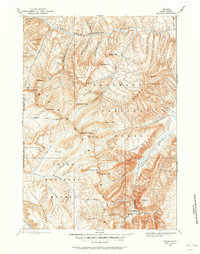 1893 Ishawooa1962 Print · USGSPark County at the end of the nineteenth century remains a wilderness of mining camps and alpine plateaus along the boundary of the nation’s first park. Trace early exploration through the Stinkingwater Mining Region and over high points like Ishawooa Pass and the Thorofare Plateau.
 - 1895 Map of Ishawooa
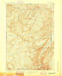 1895 Ishawooa1895 Print · USGSThe Yellowstone backcountry of the 1890s appears as a rugged high-mountain frontier in this early survey of the Shoshone and Stinkingwater drainages. Researchers can trace early high-altitude routes through Ishawooa Pass and explore the historic Stinkingwater Mining Region.
 - 1899 Map of Ishawooa
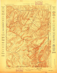 1899 Ishawooa1899 Print · USGSThe Absaroka wilderness comes into sharp focus in the 1890s, revealing the high-mountain terrain bordering the eastern edge of Yellowstone. Researchers can trace early prospecting sites in the Stinkingwater Mining Region or locate landmarks like Ishawooa Pass and Sheep Mesa.4 unique versions available
 - 1955 Map of Cody, 1969 Print
 1955 Cody1969 Print · USGSThe Bighorn Basin and Absaroka Range meet in the mid-fifties, capturing a landscape defined by mountain wilderness and burgeoning oil fields. Trace family roots in Cody or Meeteetse, and locate industrial landmarks like the Elk Basin Oil and Gas Field and the Chicago Burlington and Quincy RR.2 unique versions available
 - 1958 Map of Cody
 1958 Cody1958 Print · USGSNorthwestern Wyoming at the peak of the mid-century energy and ranching boom shows a land of high peaks and oil basins. Researchers can trace the Chicago Burlington and Quincy rail lines through Greybull or locate the sprawling Elk Basin Oil and Gas Field.
 - 1962 Map of Cody
 1962 Cody1962 Print · USGSBig Horn Basin energy and agriculture define this mid-century look at Wyoming’s northern frontier. Local historians can trace the irrigation and rail networks connecting Cody and Powell to major energy sites like the Oregon Basin Oil Field.
 - 1970 Map of Valley, 1973 Print
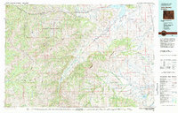
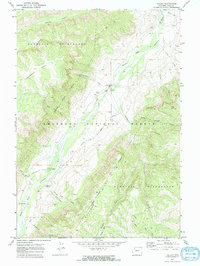 1970 Valley1973 Print · USGSHigh-country life in the 1970s centered on the South Fork Shoshone River valley and its remote outposts. Genealogists and historians can trace the foundations of this mountain community through the Valley Sch, Valley Cem, and Hawkeye.2 unique versions available
 - 1980 Map of Carter Mountain, 1982 Print
 1980 Carter Mountain1982 Print · USGSPark County at the dawn of the 1980s reveals a high-country landscape where mountain wilderness meets energy extraction. Researchers can locate remote outposts like Irma, trace the Greybull River valley, and identify the footprint of the Pitchfork Oil Field or Sunshine Reservoir.3 unique versions available
 - 1991 Map of Valley, 1997 Print
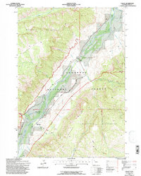 1991 Valley1997 Print · USGSIn the Wyoming high country during the 1990s, the Shoshone River corridor supported a remote mountain community amid massive wilderness reaches. Researchers can locate family landmarks like Valley Cem, the Valley Sch, and the Hawkeye settlement.
 - 2021 Map of Valley, 2021 Print
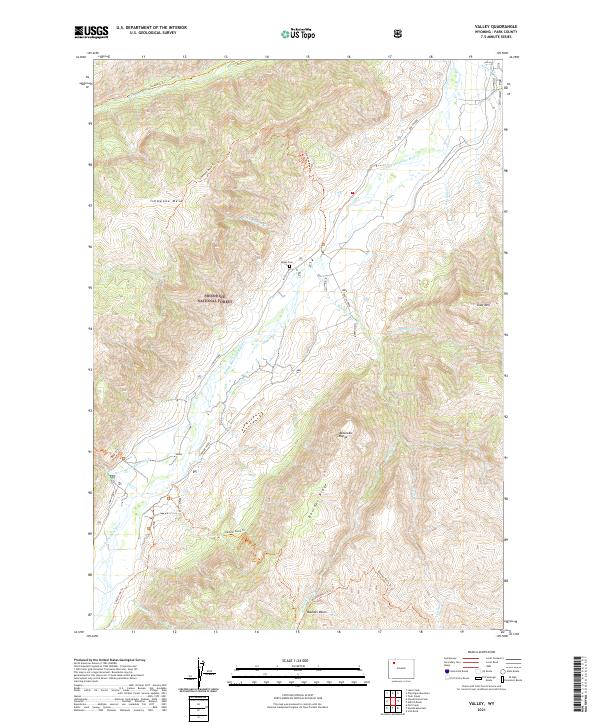 2021 Valley2021 Print · USGSThe settlement of Valley is shown in the high Absaroka backcountry during the early 2020s, centered on the river-fed valley floors. Researchers can trace the McLaughlin Ditch, locate the Valley Cem, and follow the Ishawooa Trl through the national forest.
End of results
Showing maps 1-10 of 10
Frequently asked questions
- What are the different types of historical maps available for Hawkeye?
- What is the oldest map of Hawkeye?
- Where can I purchase historical maps of Hawkeye for my home or office?
- Where can I download high-res historical maps of Hawkeye?
- Are there historical topographic maps available for Hawkeye?
- Is there historical aerial imagery available for Hawkeye?
- Where are historical maps of Hawkeye sourced from?