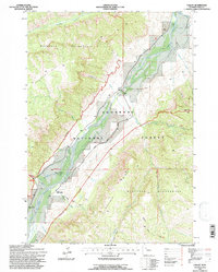
1991 Map of Valley
USGS Topo · Published 1997About this map
The South Fork Shoshone River carves a deep valley through the heart of the Shoshone National Forest, creating a narrow corridor of human activity surrounded by the high elevations of the Washakie Wilderness. This landscape is defined by massive topographic features like Ishawooa Mesa and Boulder Ridge, which constrain the limited infrastructure to the riverbanks. Within this valley, the South Fork Work Center and the Valley Sch indicate a remote but organized community presence. Land use in the late 20th century relied on water management via the Valley Ditch and access points like Hunter Road. A small settlement at Hawkeye and the Valley Cem provide specific points of interest for those tracing family history or the development of high-country outposts in Park County.
Find a feature on this map
31 named features on this map. Tap any name to fly to it.
Don’t see what you’re looking for? This feature index may not catch every label — zoom into the map to look around manually.
Map Details
Editions of this 1991 Valley Map
This is the sole edition of this map. No revisions or reprints were ever made.
Other maps of this area

1893 · Ishawooa
USGS Topo · 1:125,000

1895 · Ishawooa
USGS Topo · 1:125,000

1899 · Ishawooa
USGS Topo · 1:125,000

1955 · Cody
USGS Topo · 1:250,000

1957 · Wapiti
USGS Topo · 1:62,500

1957 · Irish Rock
USGS Topo · 1:62,500

1958 · Cody
USGS Topo · 1:250,000

1962 · Cody
USGS Topo · 1:250,000
1970 · Fall Creek
USGS Topo · 1:24,000
1970 · Ptarmigan Mountain
USGS Topo · 1:24,000