1970s Maps of Platte County, Wyoming
Explore 3 historic maps of Platte County from the 1970s. These maps offer a rare glimpse into what life looked like during the 1970s — showing old roads, neighborhoods, homes, and landmarks that have changed or disappeared over time.
Whether you're researching your family's past, planning a metal detecting trip, or studying how Platte County's landscape evolved across the 1970s, these high-resolution maps are a powerful tool for exploring the history of this region.
- Focus on a specific era: All maps on this page are from the 1970s, giving you a focused view of this time period.
- See what’s changed: Compare century-old streets, trails, and buildings to today's modern landscape using overlays and satellite layers.
- Research with precision: Use these maps for genealogy, historical research, land use analysis, or educational projects.
- View, download, or print: Maps are fully viewable online in high resolution, and can be downloaded or printed for your own records.
Start exploring Platte County's history through authentic maps from the 1970s. This is your window into the past.
Platte County, WY maps
(3)- 1971 Map of Guernsey Reservoir, 1972 Print
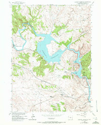 1971 Guernsey Reservoir1972 Print · USGSPioneer history and mid-century recreation meet along the North Platte River in Platte County. Researchers can trace the Emigrant Trail past the Lucinda Rollins Grave or locate the CCC Camp (Aband) near the reservoir.
 - 1978 Map of Torrington
 1978 Torrington1978 Print · USGSSoutheast Wyoming in the late seventies reveals a landscape shaped by the North Platte River and a dense network of major rail lines. Researchers can locate the Fort Laramie National Historic Site, the Camp Guernsey Training Area, and original stops along the Union Pacific railroad.2 unique versions available
 - 1978 Map of Meadowdale
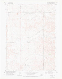 1978 Meadowdale1978 Print · USGSThe tri-county high plains of eastern Wyoming are captured here in the late 1970s, showcasing a landscape of isolated ranches and rugged geology. Researchers can locate the Meadowdale settlement and trace ranch life through features like the Rodeo Ground and Little Flattop.
End of results
Showing maps 1-3 of 3
Top cities of Platte County
- Wheatland historical maps
- Guernsey historical maps
- Chugwater historical maps
- Glendo historical maps
- Hartville historical maps
Frequently asked questions
- What are the different types of historical maps available for Platte County?
- What is the oldest map of Platte County?
- Where can I purchase historical maps of Platte County for my home or office?
- Where can I download high-res historical maps of Platte County?
- Are there historical topographic maps available for Platte County?
- Is there historical aerial imagery available for Platte County?
- Where are historical maps of Platte County sourced from?