1940s Maps of Platte County, Wyoming
Explore 6 historic maps of Platte County from the 1940s. These maps offer a rare glimpse into what life looked like during the 1940s — showing old roads, neighborhoods, homes, and landmarks that have changed or disappeared over time.
Whether you're researching your family's past, planning a metal detecting trip, or studying how Platte County's landscape evolved across the 1940s, these high-resolution maps are a powerful tool for exploring the history of this region.
- Focus on a specific era: All maps on this page are from the 1940s, giving you a focused view of this time period.
- See what’s changed: Compare century-old streets, trails, and buildings to today's modern landscape using overlays and satellite layers.
- Research with precision: Use these maps for genealogy, historical research, land use analysis, or educational projects.
- View, download, or print: Maps are fully viewable online in high resolution, and can be downloaded or printed for your own records.
Start exploring Platte County's history through authentic maps from the 1940s. This is your window into the past.
Platte County, WY maps
(6)- 1943 Map of Esterbrook, 1963 Print
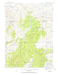 1943 Esterbrook1963 Print · USGSThe Laramie Range high country comes into focus in the early 1940s, showing a landscape of remote mountain ranches and forest lookouts. Researchers can trace historic family holdings like La Bonte Ranch and find small rural schoolhouses such as Morton Sch and Hanks Sch.
 - 1945 Map of Esterbrook
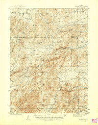 1945 Esterbrook1945 Print · USGSThe Converse and Albany county line in the 1940s reveals a high-plains landscape of remote mountain schools and family ranches. Genealogists can locate family landmarks like La Bonte Ranch and Morton Sch or trace the old Horseshoe Trail.2 unique versions available
 - 1949 Map of Cedar Top, 1963 Print
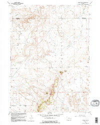 1949 Cedar Top1963 Print · USGSThe Platte and Niobrara county line runs through this Wyoming landscape in the late 1940s. Local history researchers can trace landmarks like the Spanish Diggings, Sheep Mountain, and the unique Spouting Spring.2 unique versions available
 - 1949 Map of Cedar Hill, 1967 Print
 1949 Cedar Hill1967 Print · USGSRanching life on the Converse and Platte county line is documented here during the late 1940s, showing a landscape defined by water and wind. Researchers can trace the heritage of the Fitzhugh Ranch or locate water sources like Bog Hole Springs and North Elkhorn Creek.2 unique versions available
 - 1949 Map of Spring Creek, 1970 Print
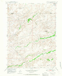
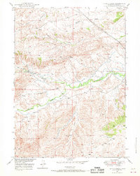 1949 Spring Creek1970 Print · USGSIn the late 1940s, this Wyoming ranching landscape relied on a critical network of water management and seasonal drainages. Researchers can trace the early irrigation patterns of Horseshoe Creek and locate family-named landmarks like Pollard Hill and Reeder Draw.2 unique versions available
 - 1949 Map of Dilts Ranch, 1975 Print
 1949 Dilts Ranch1975 Print · USGSCentral Wyoming ranching country is documented here just after the war, where the historic Emigrant Trail crosses the high plains. Researchers can trace the wagon route past the Oregon Trail Monument or locate early family holdings like Dilts Ranch and Elkhorn Ranch.
End of results
Showing maps 1-6 of 6
Top cities of Platte County
- Wheatland historical maps
- Guernsey historical maps
- Chugwater historical maps
- Glendo historical maps
- Hartville historical maps
Frequently asked questions
- What are the different types of historical maps available for Platte County?
- What is the oldest map of Platte County?
- Where can I purchase historical maps of Platte County for my home or office?
- Where can I download high-res historical maps of Platte County?
- Are there historical topographic maps available for Platte County?
- Is there historical aerial imagery available for Platte County?
- Where are historical maps of Platte County sourced from?