1960s Maps of Platte County, Wyoming
Explore 13 historic maps of Platte County from the 1960s. These maps offer a rare glimpse into what life looked like during the 1960s — showing old roads, neighborhoods, homes, and landmarks that have changed or disappeared over time.
Whether you're researching your family's past, planning a metal detecting trip, or studying how Platte County's landscape evolved across the 1960s, these high-resolution maps are a powerful tool for exploring the history of this region.
- Focus on a specific era: All maps on this page are from the 1960s, giving you a focused view of this time period.
- See what’s changed: Compare century-old streets, trails, and buildings to today's modern landscape using overlays and satellite layers.
- Research with precision: Use these maps for genealogy, historical research, land use analysis, or educational projects.
- View, download, or print: Maps are fully viewable online in high resolution, and can be downloaded or printed for your own records.
Start exploring Platte County's history through authentic maps from the 1960s. This is your window into the past.
Platte County, WY maps
(13)- 1961 Map of Glendo, 1965 Print
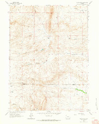
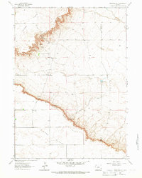
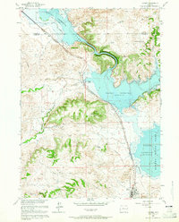 1961 Glendo1965 Print · USGSEastern Wyoming in the early sixties shows a landscape transformed by the Glendo Reservoir and the Chicago Burlington and Quincy rail line. Researchers can find the town of Glendo and remote landmarks like Buffalo Springs and Red Canyon.3 unique versions available
 - 1961 Map of Sibley Peak, 1965 Print
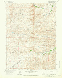
 1961 Sibley Peak1965 Print · USGSThe High Plains of Platte County come alive in this early sixties survey, where the path of the Emigrant Trail meets modern rails. Researchers can locate the Pony Express Sta, the Horseshoe Cem, and family landmarks like Sommers Hill.2 unique versions available
 - 1961 Map of Cassa, 1965 Print
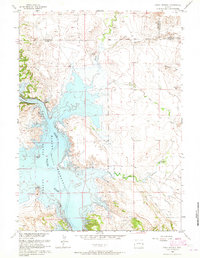
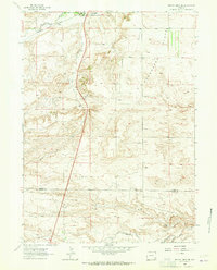
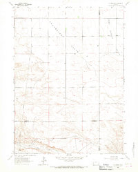
 1961 Cassa1965 Print · USGSThe North Platte River corridor is seen here in the early sixties, just as the new reservoir and dam were reshaping the local topography. Genealogists and historians can trace the historic Emigrant Trail and the Chicago Burlington and Quincy rail line near Cassa.3 unique versions available
 - 1961 Map of Jewel Springs, 1965 Print
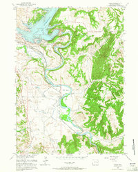
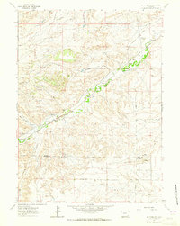
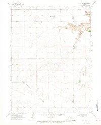
 1961 Jewel Springs1965 Print · USGSThe North Platte River valley is captured in the early sixties just after the creation of the Glendo Reservoir. Genealogists and historians can trace the historic Emigrant Trail across the plains near Jewel Springs and Crandall Dam.
 - 1962 Map of Delano Ranch, 1964 Print
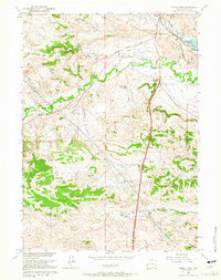
 1962 Delano Ranch1964 Print · USGSSoutheast Wyoming ranching life is well-documented in the early sixties as the high plains terrain meets the Laramie County line. Researchers can trace the water rights and boundaries of the Delano Ranch, Miller Ranch, and Mule Creek.2 unique versions available
 - 1962 Map of Mc Donald Ranch, 1964 Print
 1962 Mc Donald Ranch1964 Print · USGSRanching life on the Platte and Laramie county line comes into focus in the early sixties, centered on the drainage of Chugwater Creek. Local researchers can trace family land at McDonald Ranch and locate the former McDonald Sch near the Colorado and Southern railroad.3 unique versions available
 - 1962 Map of Bristol Ridge NE, 1965 Print
 1962 Bristol Ridge NE1965 Print · USGSThe high plains of Wyoming are captured here in the early sixties, illustrating the critical transportation corridor between Platte and Laramie counties. Researchers can trace the Colorado and Southern railroad, find family landmarks near Bristol Ridge, and locate natural features like Mud Spring.2 unique versions available
 - 1962 Map of Whitcomb Hill, 1965 Print
 1962 Whitcomb Hill1965 Print · USGSThe high plains along the Platte and Laramie county line are captured here in the early sixties, showing a landscape of cattle ranching and rail. Researchers can trace the legacy of local landmarks like Whitcomb Ranch, the remote Chalk Hill Sch, and the Colorado and Southern railroad line.2 unique versions available
 - 1963 Map of Dickinson Hill, 1967 Print
 1963 Dickinson Hill1967 Print · USGSThe high plains of Platte and Goshen Counties are documented here in the early sixties, centered on the striking escarpment of the Goshen Hole Rim. Researchers can trace old ranching landmarks and infrastructure such as Baker Ranch, the Wind Charger, and Swan.2 unique versions available
 - 1963 Map of C S Ranch, 1967 Print
 1963 C S Ranch1967 Print · USGSHigh plains ranching life in the 1960s is preserved on this sheet where Platte, Goshen, and Laramie counties meet. Local researchers can trace family-named landmarks like C S Ranch and A X Ranch situated between Chugwater Flats and Bear Creek.2 unique versions available
 - 1963 Map of Klutz Canyon, 1967 Print
 1963 Klutz Canyon1967 Print · USGSThe high plains of Platte and Goshen counties come to life in the mid-1960s, showing a ranching landscape defined by its essential springs and wide flats. Trace local history at Town Center Flats Ch or explore the deep cuts of Klutz Canyon and Box Elder Canyon.2 unique versions available
 - 1968 Map of Reese Mountain, 1972 Print
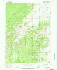
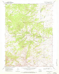 1968 Reese Mountain1972 Print · USGSThe high Laramie Range of Albany County is captured here in the late 1960s, showing a rugged landscape of national forest and mountain peaks. Researchers can locate remote sites like the Marble Quarry and trace the paths of Laramie River and Collins Creek.2 unique versions available
 - 1968 Map of Fletcher Park, 1972 Print
 1968 Fletcher Park1972 Print · USGSThe Albany and Platte county line in the late 1960s shows a landscape of mountain forestry and rugged trails. Genealogists and historians can trace the paths around Hanks Sawmill, Camp Grace, and landmarks like Chimney Rock and Indian Head Rock.3 unique versions available
End of results
Showing maps 1-13 of 13
Top cities of Platte County
- Wheatland historical maps
- Guernsey historical maps
- Chugwater historical maps
- Glendo historical maps
- Hartville historical maps
Frequently asked questions
- What are the different types of historical maps available for Platte County?
- What is the oldest map of Platte County?
- Where can I purchase historical maps of Platte County for my home or office?
- Where can I download high-res historical maps of Platte County?
- Are there historical topographic maps available for Platte County?
- Is there historical aerial imagery available for Platte County?
- Where are historical maps of Platte County sourced from?