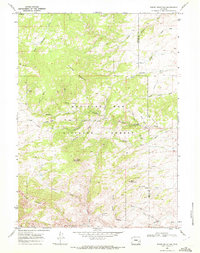
1968 Map of Reese Mountain
USGS Topo · Published 1972This historical map portrays the area of Reese Mountain in 1968, primarily covering Albany County as well as portions of Platte County. Featuring a scale of 1:24000, this map provides a highly detailed snapshot of the terrain, roads, buildings, counties, and historical landmarks in the Reese Mountain region at the time. Published in 1972, it is one of 2 known editions of this map due to revisions or reprints.
Find a feature on this map
44 named features on this map. Tap any name to fly to it.
Don’t see what you’re looking for? This feature index may not catch every label — zoom into the map to look around manually.
Map Details
Editions of this 1968 Reese Mountain Map
2 editions found
Historical Maps of Platte County Through Time
104 maps found

1948 Ragged Top Mountain
Albany County, WY

1948 Sherman Mountains
Albany County, WY

1950 Ragged Top Mountain
Albany County, WY

1950 Sherman Mountains
Albany County, WY

1955 Ayres Spring
Albany County, WY

1955 Baldy Mountain
Albany County, WY

1955 Big Judson
Albany County, WY

1955 Bluegrass Wells
Albany County, WY

1955 Bosler
Albany County, WY

1955 Bosler SE
Albany County, WY

1955 Bull Camp Peak
Albany County, WY

1955 Cannonball Cut
Albany County, WY

1955 Cooper Lake North
Albany County, WY

1955 Cooper Lake South
Albany County, WY

1955 Dodge Ranch
Albany County, WY

1955 Goat Mountain
Albany County, WY

1955 Guide Rock
Albany County, WY

1955 Indian Guide
Albany County, WY

1955 Lake Ione
Albany County, WY

1955 Mc Gill Lakes
Albany County, WY

1955 Moonshine Peak
Albany County, WY

1955 Pine Tree Ridge
Albany County, WY

1955 Poe Mountain
Albany County, WY

1955 Sevenmile Spring
Albany County, WY

1955 Sheep Rock
Albany County, WY

1955 Sybille Springs
Albany County, WY

1955 Wilcox
Albany County, WY

1958 Bengough Hill
Albany County, WY

1958 Pierce Reservoir
Albany County, WY

1959 Chalk Hills
Albany County, WY

1961 Big Charlie Lakes
Albany County, WY

1961 Foxpark
Albany County, WY

1961 Horatio Rock
Albany County, WY

1961 Keystone
Albany County, WY

1961 Lake Owen
Albany County, WY

1961 Medicine Bow Peak
Albany County, WY

1961 Rex Lake
Albany County, WY

1961 Strouss Hill
Albany County, WY

1961 Walker Draw SE
Albany County, WY

1961 Woods Landing
Albany County, WY

1962 Millbrook
Albany County, WY

1962 Miller
Albany County, WY

1963 Alsop Lake
Albany County, WY

1963 Bamforth Lake
Albany County, WY

1963 Best Ranch
Albany County, WY

1963 Caldwell Lake
Albany County, WY

1963 Downey Lakes
Albany County, WY

1963 Howell
Albany County, WY

1963 Hutton Lake
Albany County, WY

1963 James Lake
Albany County, WY

1963 Jelm Mountain
Albany County, WY

1963 Johnson Ranch
Albany County, WY

1963 Laramie SW
Albany County, WY

1963 Red Buttes
Albany County, WY

1963 Sodergreen Lake
Albany County, WY

1964 Marshall
Albany County, WY

1964 Pass Creek
Albany County, WY

1964 Toltec
Albany County, WY

1968 Boot Heel
Albany County, WY

1968 Boot Heel SE
Albany County, WY

1968 Cottonwood Creek
Albany County, WY

1968 Cow Creek Mountain
Albany County, WY

1968 Davidson Flats
Albany County, WY

1968 Fletcher Park
Albany County, WY

1968 Garrett
Albany County, WY

1968 Greasewood Knoll
Albany County, WY

1968 Pinto Creek
Albany County, WY

1968 Reese Mountain
Albany County, WY

1968 Rogers Creek
Albany County, WY

1968 South Mountain
Albany County, WY

1971 Aurora Lake
Albany County, WY

1971 Foote Creek Lake
Albany County, WY

1981 Laramie Peak
Albany County, WY

1985 Harris Park
Albany County, WY

1987 Buford
Albany County, WY

1987 Dale Creek
Albany County, WY

1987 Green Top Mountain
Albany County, WY

1987 King Mountain
Albany County, WY

1987 Pilot Hill
Albany County, WY

1987 Ragged Top Mountain
Albany County, WY

1987 Sherman Mountains East
Albany County, WY

1987 Sherman Mountains West
Albany County, WY

1992 Cottonwood Creek
Albany County, WY

1992 Cow Creek Mtn
Albany County, WY

1992 Davidson Flats
Albany County, WY

1992 Fletcher Park
Albany County, WY

1992 Foxpark
Albany County, WY

1992 Green Top Mountain
Albany County, WY

1992 Harris Park
Albany County, WY

1992 Keystone
Albany County, WY

1992 Lake Owen
Albany County, WY

1992 Marshall
Albany County, WY

1992 Medicine Bow Peak
Albany County, WY

1992 Millbrook
Albany County, WY

1992 Pilot Hill
Albany County, WY

1992 Reese Mountain
Albany County, WY

1992 Rex Lake
Albany County, WY

1992 Sherman Mountains East
Albany County, WY

1992 Sherman Mountains West
Albany County, WY

1992 Sodergreen Lake
Albany County, WY

1992 South Mountain
Albany County, WY

1992 Strouss Hill
Albany County, WY

1992 Toltec
Albany County, WY

1992 Woods Landing
Albany County, WY