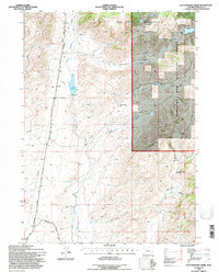
1992 Map of Cottonwood Creek
USGS Topo · Published 1996About this map
Fort Fetterman Road bisects this high-elevation landscape, following a historic transportation corridor through the north-central Wyoming ranchlands. The map reveals a remote pastoral economy dependent on water sources like the North Laramie River and Toltec Reservoir. Educational and logistical hubs are few, represented by the isolated Antelope Creek Sch and a mountain Airstrip situated near the eastern boundary of the Medicine Bow National Forest. Dramatic elevation changes are marked by distinctive landmarks such as Bar M Mountain and Indian Head Rock. The drainage patterns of Cottonwood Creek and Antelope Creek define the local topography, which is crisscrossed by secondary routes like Garrett Road and the Harvey Trail, illustrating the rugged connectivity required in the Albany County backcountry during the late twentieth century.
Find a feature on this map
21 named features on this map. Tap any name to fly to it.
Don’t see what you’re looking for? This feature index may not catch every label — zoom into the map to look around manually.
Map Details
Editions of this 1992 Cottonwood Creek Map
This is the sole edition of this map. No revisions or reprints were ever made.
Other maps of this area

1954 · Torrington
USGS Topo · 1:250,000

1958 · Torrington
USGS Topo · 1:250,000

1964 · Toltec
USGS Topo · 1:24,000

1964 · Windy Peak
USGS Topo · 1:24,000

1964 · Marshall
USGS Topo · 1:24,000

1968 · Cow Creek Mountain
USGS Topo · 1:24,000

1968 · Cottonwood Creek
USGS Topo · 1:24,000
1968 · Rogers Creek
USGS Topo · 1:24,000
1968 · Garrett
USGS Topo · 1:24,000
1968 · Boot Heel SE
USGS Topo · 1:24,000