
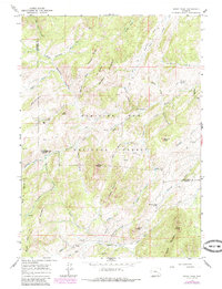
1964 Map of Windy Peak
USGS Topo · Published 1968About this map
Medicine Bow National Forest encompasses the high-altitude terrain shown in this mid-1960s survey, straddling the border of Albany and Converse Counties. The landscape is defined by its complex hydrology, with waters flowing through the Roaring Fork and Horseshoe Creek drainages. Human activity is sparse, marked by isolated infrastructure like the Prager Sch and the evocative Graveyard Hill located in the southern portion of the quadrangle. Several prospect sites indicate historical mineral exploration near Trethway Mountain and Silver Creek.
Find a feature on this map
58 named features on this map. Tap any name to fly to it.
Don’t see what you’re looking for? This feature index may not catch every label — zoom into the map to look around manually.
Map Details
Editions of this 1964 Windy Peak Map
2 editions found
Other maps of this area

1943 · Esterbrook
USGS Topo · 1:62,500

1945 · Esterbrook
USGS Topo · 1:62,500

1954 · Torrington
USGS Topo · 1:250,000

1958 · Torrington
USGS Topo · 1:250,000

1964 · Toltec
USGS Topo · 1:24,000

1964 · School Section Mountain
USGS Topo · 1:24,000

1964 · Saddleback Mountain
USGS Topo · 1:24,000

1968 · Cow Creek Mountain
USGS Topo · 1:24,000

1968 · Cottonwood Creek
USGS Topo · 1:24,000
1968 · South Mountain
USGS Topo · 1:24,000