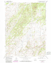
1968 Map of Cow Creek Mountain
USGS Topo · Published 1985About this map
Medicine Bow National Forest dominates this section of Albany County, Wyoming, where the high ridges of Eagle Mountain and Sugarloaf Mountain overlook a complex network of drainage basins. The landscape is defined by its verticality, with named summits like Jack Squirrel Peak, Blue Jay Mountain, and Indian Peak rising above the deep canyons and draws. Human activity is sparse and concentrated near water sources, evidenced by the C U Ranch and the small Buckland settlement.
Find a feature on this map
38 named features on this map. Tap any name to fly to it.
Don’t see what you’re looking for? This feature index may not catch every label — zoom into the map to look around manually.
Map Details
Editions of this 1968 Cow Creek Mountain Map
2 editions found
Other maps of this area

1943 · Esterbrook
USGS Topo · 1:62,500

1945 · Esterbrook
USGS Topo · 1:62,500

1954 · Torrington
USGS Topo · 1:250,000

1958 · Torrington
USGS Topo · 1:250,000

1964 · Toltec
USGS Topo · 1:24,000

1964 · Windy Peak
USGS Topo · 1:24,000

1968 · Cow Creek Mountain
USGS Topo · 1:24,000

1968 · Davidson Flats
USGS Topo · 1:24,000

1968 · Cottonwood Creek
USGS Topo · 1:24,000
1968 · South Mountain
USGS Topo · 1:24,000