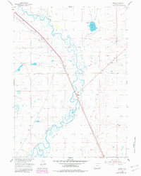
1955 Map of Bosler
USGS Topo · Published 1982About this map
Laramie River meanders sharply through this high plains landscape, defining the character of the settlement at Bosler during the mid-20th century. The town and nearby Bosler Junction sit as critical waypoints along the Union Pacific railroad, which cuts a straight diagonal through the terrain. This survey, updated with 1979 aerial photography, highlights a complex water management system essential to the high-altitude ranching economy. A network of man-made waterways, including the Boughton Canal, Oasis Ditch, and James Lake North Canal, feeds into local reservoirs like Diamond Lake. The presence of an Abandoned Canal suggests shifts in irrigation and land use over time, while the Diamond Ranch signifies the enduring presence of large-scale cattle operations in Albany County.
Find a feature on this map
10 named features on this map. Tap any name to fly to it.
Don’t see what you’re looking for? This feature index may not catch every label — zoom into the map to look around manually.
Map Details
Editions of this 1955 Bosler Map
2 editions found
Other maps of this area

1895 · Laramie
USGS Topo · 1:125,000

1902 · Laramie
USGS Topo · 1:125,000

1905 · Laramie
USGS Topo · 1:125,000

1906 · Laramie
USGS Topo · 1:125,000

1908 · Laramie
USGS Topo · 1:125,000

1954 · Cheyenne
USGS Topo · 1:250,000

1955 · Bosler
USGS Topo · 1:24,000

1955 · Bosler SE
USGS Topo · 1:24,000

1955 · Cooper Lake South
USGS Topo · 1:24,000

1955 · Sybille Springs
USGS Topo · 1:24,000