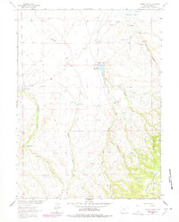
1963 Map of Johnson Ranch
USGS Topo · Published 1978About this map
Lone Tree Creek and Antelope Creek carve through this high-plains landscape in Albany County, where mid-century ranching operations defined the local geography. The map documents a sparsely populated but active livestock corridor, anchored by the Johnson Ranch, Five Mile Ranch, and Chimney Rock Ranch. Water management is central to life here, evidenced by the large Aqueduct running across the northern sections and the creation of Sportsman Lake and the Lone Tree Reservoir. These features, along with numerous unnamed springs, provided the necessary infrastructure for agriculture in a region marked by the prominent elevation of Boulder Ridge. Small-scale social infrastructure, such as the Sand Creek Sch near the western edge, indicates where families once gathered in this expansive ranching district north of the Colorado state line.
Find a feature on this map
20 named features on this map. Tap any name to fly to it.
Don’t see what you’re looking for? This feature index may not catch every label — zoom into the map to look around manually.
Map Details
Editions of this 1963 Johnson Ranch Map
3 editions found
Other maps of this area

1895 · Laramie
USGS Topo · 1:125,000

1902 · Laramie
USGS Topo · 1:125,000

1905 · Laramie
USGS Topo · 1:125,000

1906 · Laramie
USGS Topo · 1:125,000

1908 · Laramie
USGS Topo · 1:125,000

1916 · Home
USGS Topo · 1:125,000

1920 · Home
USGS Topo · 1:125,000

1954 · Cheyenne
USGS Topo · 1:250,000

1954 · Greeley
USGS Topo · 1:250,000

1957 · Greeley
USGS Topo · 1:250,000