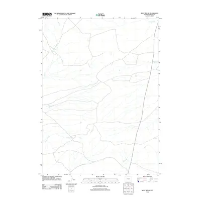
2012 Map of Boot Heel SE
USGS Topo · Published 2012About this map
Twentytwo Mile Reservoir and Twentymile Reservoir anchor the northeastern drainage of this high-plains landscape in Albany County. The map details a sophisticated network of ephemeral watercourses and livestock water management infrastructure essential to the region's ranching economy. Significant drainages such as Bone Cr in the northwest and Greasewood Cr in the south define the topographical flow of the territory. The sparse settlement pattern is reflected in the long stretches of unimproved roads and four-wheel-drive trails that connect remote sections of the county, providing a clear record of land use and accessibility in the early 21st century. This survey documents the subtle hydrologic features of the Wyoming steppe before modern shifts in water management or climate could alter the footprint of these essential reservoirs.
Find a feature on this map
4 named features on this map. Tap any name to fly to it.
Don’t see what you’re looking for? This feature index may not catch every label — zoom into the map to look around manually.
Map Details
Editions of this 2012 Boot Heel SE Map
This is the sole edition of this map. No revisions or reprints were ever made.
Other maps of this area

1954 · Torrington
USGS Topo · 1:250,000

1954 · Cheyenne
USGS Topo · 1:250,000

1955 · Pine Tree Ridge
USGS Topo · 1:24,000

1955 · Sevenmile Spring
USGS Topo · 1:24,000

1955 · Ayres Spring
USGS Topo · 1:24,000

1958 · Cheyenne
USGS Topo · 1:250,000

1958 · Torrington
USGS Topo · 1:250,000

1968 · Cottonwood Creek
USGS Topo · 1:24,000
1968 · Boot Heel
USGS Topo · 1:24,000
1968 · Greasewood Knoll
USGS Topo · 1:24,000