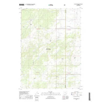
2017 Map of Fletcher Park
USGS Topo · Published 2017About this map
The high drainage basins of Medicine Bow National Forest dominate this landscape along the border of Albany and Platte counties. The terrain is defined by a series of open parks and flats, including Fletcher Park, Cottonwood Park, and Elk Park, which suggest a long history of high-altitude grazing or seasonal encampments. Local transportation is facilitated by named access routes like Fletcher Park Rd and Van Ortrick Hill Rd, connecting isolated topographic features. The hydrologic network is intricate, with the N Laramie River and its tributaries such as Lone Tree Cr and Claude Irvine Cr carving through the plateau. Notable rock formations like Indian Head Rock and Chimney Rock serve as distinct navigational landmarks in this corner of the Wyoming wilderness.
Find a feature on this map
33 named features on this map. Tap any name to fly to it.
Don’t see what you’re looking for? This feature index may not catch every label — zoom into the map to look around manually.
Map Details
Editions of this 2017 Fletcher Park Map
This is the sole edition of this map. No revisions or reprints were ever made.
Other maps of this area

1943 · Esterbrook
USGS Topo · 1:62,500

1945 · Esterbrook
USGS Topo · 1:62,500

1950 · Cottonwood Falls
USGS Topo · 1:24,000

1951 · Cottonwood Falls
USGS Topo · 1:24,000

1953 · Hightower SW
USGS Topo · 1:24,000

1953 · Johnson Mountain
USGS Topo · 1:24,000

1954 · Torrington
USGS Topo · 1:250,000

1958 · Torrington
USGS Topo · 1:250,000

1968 · Davidson Flats
USGS Topo · 1:24,000
1968 · Reese Mountain
USGS Topo · 1:24,000