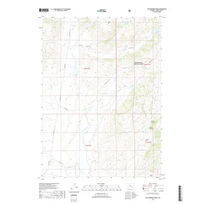
2017 Map of Cottonwood Creek
USGS Topo · Published 2017About this map
Medicine Bow National Forest dominates the eastern landscape of this high-elevation Wyoming survey, where cattle ranching and water management define the local geography. Significant water infrastructure is evident through features like Joe Ditch, Bar M Number 3 Reservoir, and Newell Reservoir, all essential for supporting agriculture in the drainage basin of the N Laramie River. The terrain is marked by distinct landmarks such as Bar M Mtn and Indian Head Rock, while a network of rural routes including Fetterman Rd and Esterbrook Rd provide access through the complex system of draws and creeks. This 2017 edition records the modern state of these public and private lands, illustrating the enduring importance of seasonal watercourses like Cottonwood Cr and Antelope Cr to the region’s topography.
Find a feature on this map
24 named features on this map. Tap any name to fly to it.
Don’t see what you’re looking for? This feature index may not catch every label — zoom into the map to look around manually.
Map Details
Editions of this 2017 Cottonwood Creek Map
This is the sole edition of this map. No revisions or reprints were ever made.
Other maps of this area

1954 · Torrington
USGS Topo · 1:250,000

1958 · Torrington
USGS Topo · 1:250,000

1964 · Toltec
USGS Topo · 1:24,000

1964 · Windy Peak
USGS Topo · 1:24,000

1964 · Marshall
USGS Topo · 1:24,000

1968 · Cow Creek Mountain
USGS Topo · 1:24,000

1968 · Cottonwood Creek
USGS Topo · 1:24,000
1968 · Rogers Creek
USGS Topo · 1:24,000
1968 · Garrett
USGS Topo · 1:24,000
1968 · Boot Heel SE
USGS Topo · 1:24,000