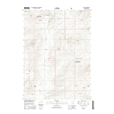
2015 Map of Toltec
USGS Topo · Published 2015About this map
Toltec and Squaw Place sit within a high-elevation ranching landscape in the southern Laramie Mountains. This area of Albany County is defined by the headwaters of several drainages, including the N Laramie River and La Bonte Cr. The terrain is marked by prominent peaks such as Fortymile Peak and Mule Creek Mtn, with the historic Fetterman Rd providing a primary north-south transit route through the mountains.
Find a feature on this map
61 named features on this map. Tap any name to fly to it.
Don’t see what you’re looking for? This feature index may not catch every label — zoom into the map to look around manually.
Map Details
Editions of this 2015 Toltec Map
This is the sole edition of this map. No revisions or reprints were ever made.
Other maps of this area

1954 · Torrington
USGS Topo · 1:250,000

1958 · Torrington
USGS Topo · 1:250,000

1964 · Toltec
USGS Topo · 1:24,000

1964 · School Section Mountain
USGS Topo · 1:24,000

1964 · Saddleback Mountain
USGS Topo · 1:24,000

1964 · Windy Peak
USGS Topo · 1:24,000

1964 · Marshall
USGS Topo · 1:24,000
1964 · Warbonnet Peak
USGS Topo · 1:24,000

1968 · Cow Creek Mountain
USGS Topo · 1:24,000

1968 · Cottonwood Creek
USGS Topo · 1:24,000