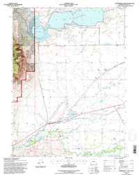
1992 Map of Sodergreen Lake
USGS Topo · Published 1996About this map
Sheep Mountain rises sharply at the western edge of this Wyoming landscape, defining the eastern boundary of the Medicine Bow National Forest. This high-altitude basin is defined by an intricate network of irrigation engineering, where the Laramie River feeds into a series of named ditches and canals designed to sustain the region's agricultural life. Major water bodies like Lake Hattie Reservoir, Russell Lake, and Sodergreen Lake dominate the terrain, connected by the Hattie Supply Canal and the Pioneer Canal.
Find a feature on this map
44 named features on this map. Tap any name to fly to it.
Don’t see what you’re looking for? This feature index may not catch every label — zoom into the map to look around manually.
Map Details
Editions of this 1992 Sodergreen Lake Map
This is the sole edition of this map. No revisions or reprints were ever made.
Other maps of this area

1895 · Laramie
USGS Topo · 1:125,000

1902 · Laramie
USGS Topo · 1:125,000

1905 · Laramie
USGS Topo · 1:125,000

1906 · Medicine Bow
USGS Topo · 1:125,000

1906 · Laramie
USGS Topo · 1:125,000

1908 · Laramie
USGS Topo · 1:125,000

1908 · Medicine Bow
USGS Topo · 1:125,000

1954 · Cheyenne
USGS Topo · 1:250,000

1954 · Rawlins
USGS Topo · 1:250,000

1958 · Rawlins
USGS Topo · 1:250,000