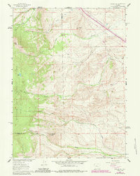
1961 Map of Strouss Hill
USGS Topo · Published 1984About this map
The historic Overland Trail cuts across the northern reaches of this high-elevation landscape, marking a legacy of westward migration through Wyoming. To the west, the boundaries of the Medicine Bow National Forest encompass the high peaks and timberline, while the lower slopes are defined by a network of drainage systems including Fourmile Creek and Sevenmile Creek. This period of land use shows a transition between traditional cattle ranching at Manthos Ranch and Basin Ranch and mid-century industrial interests, evidenced by several Oil Wells and multiple prospects scattered near Strouss Hill.
Find a feature on this map
27 named features on this map. Tap any name to fly to it.
Don’t see what you’re looking for? This feature index may not catch every label — zoom into the map to look around manually.
Map Details
Editions of this 1961 Strouss Hill Map
3 editions found
Other maps of this area

1895 · Laramie
USGS Topo · 1:125,000

1902 · Laramie
USGS Topo · 1:125,000

1905 · Laramie
USGS Topo · 1:125,000

1906 · Medicine Bow
USGS Topo · 1:125,000

1906 · Laramie
USGS Topo · 1:125,000

1908 · Laramie
USGS Topo · 1:125,000

1908 · Medicine Bow
USGS Topo · 1:125,000

1954 · Cheyenne
USGS Topo · 1:250,000

1954 · Rawlins
USGS Topo · 1:250,000

1955 · Big Judson
USGS Topo · 1:24,000