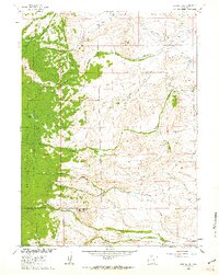
1961 Map of Strouss Hill
USGS Topo · Published 1963About this map
The Overland Trail cuts across the northern reaches of this Wyoming landscape, marking a historical passage through the high-elevation terrain of the Medicine Bow National Forest. In the early 1960s, the region was characterized by isolated cattle operations like Mantle Ranch and Bunn Ranch, set against a backdrop of prominent summits including Strouss Hill, Coyote Hill, and Bunker Hill. The drainage patterns are intricate, with Sevenmile Creek and Cooper Creek carving through the slopes, supported by the Straus Ditch No 2 irrigation system. Scattered oil wells and mineral prospects indicate a geography of extraction, while various trails and the occasional pipeline reflect the post-war development of the Missouri River Basin. This survey captures a moment when traditional ranching and emerging industrial interests shared the rugged divide between Carbon and Albany counties.
Find a feature on this map
29 named features on this map. Tap any name to fly to it.
Don’t see what you’re looking for? This feature index may not catch every label — zoom into the map to look around manually.
Map Details
Editions of this 1961 Strouss Hill Map
3 editions found
Other maps of this area

1895 · Laramie
USGS Topo · 1:125,000

1902 · Laramie
USGS Topo · 1:125,000

1905 · Laramie
USGS Topo · 1:125,000

1906 · Medicine Bow
USGS Topo · 1:125,000

1906 · Laramie
USGS Topo · 1:125,000

1908 · Laramie
USGS Topo · 1:125,000

1908 · Medicine Bow
USGS Topo · 1:125,000

1954 · Cheyenne
USGS Topo · 1:250,000

1954 · Rawlins
USGS Topo · 1:250,000

1955 · Big Judson
USGS Topo · 1:24,000