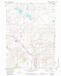
1958 Map of Bengough Hill
USGS Topo · Published 1983About this map
The Overland Trail cuts across the high plains of the Laramie Basin, tracing a historic path through a landscape defined by ranching and early petroleum development. This mid-century survey reveals a complex water management system essential for this arid region, featuring various irrigation structures like Twomile Ditch, Canon Ditch, and the Northrop Ditch No 1. The map documents the spatial relationship between traditional land use at Dunn Ranch and Jankovsky Ranch and the industrial footprint of the Dutton Creek Oil Field and Cooper Cove Oil Field. Numerous water bodies, including King Reservoir No 1 and Bosler Reservoir (Diamond Lake), punctuate the terrain near Bengough Hill. The boundary between Carbon and Albany counties is clearly delineated, crossing several seasonal drainages such as Sheep Creek and Dutton Creek.
Find a feature on this map
30 named features on this map. Tap any name to fly to it.
Don’t see what you’re looking for? This feature index may not catch every label — zoom into the map to look around manually.
Map Details
Editions of this 1958 Bengough Hill Map
2 editions found

Other maps of this area

1895 · Laramie
USGS Topo · 1:125,000

1902 · Laramie
USGS Topo · 1:125,000

1905 · Laramie
USGS Topo · 1:125,000

1906 · Medicine Bow
USGS Topo · 1:125,000

1906 · Laramie
USGS Topo · 1:125,000

1908 · Laramie
USGS Topo · 1:125,000

1908 · Medicine Bow
USGS Topo · 1:125,000

1954 · Cheyenne
USGS Topo · 1:250,000

1954 · Rawlins
USGS Topo · 1:250,000

1955 · Big Judson
USGS Topo · 1:24,000