
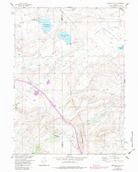
1958 Map of Bengough Hill
USGS Topo · Published 1959About this map
Industrial energy and early western transit routes converge in this 1958 survey of Albany and Carbon counties. The Overland Trail cuts across the center of the landscape, marking a path for historic emigrant travel that predates the modern infrastructure seen elsewhere on the sheet. The local economy of the late 1950s is defined by resource extraction, anchored by the Dutton Creek Oil Field and Cooper Cove Oil Field, where numerous gas wells and pumping stations are distributed among the high-plains terrain.
Find a feature on this map
28 named features on this map. Tap any name to fly to it.
Don’t see what you’re looking for? This feature index may not catch every label — zoom into the map to look around manually.
Map Details
Editions of this 1958 Bengough Hill Map
2 editions found
Other maps of this area

1895 · Laramie
USGS Topo · 1:125,000

1902 · Laramie
USGS Topo · 1:125,000

1905 · Laramie
USGS Topo · 1:125,000

1906 · Medicine Bow
USGS Topo · 1:125,000

1906 · Laramie
USGS Topo · 1:125,000

1908 · Laramie
USGS Topo · 1:125,000

1908 · Medicine Bow
USGS Topo · 1:125,000

1954 · Cheyenne
USGS Topo · 1:250,000

1954 · Rawlins
USGS Topo · 1:250,000

1955 · Big Judson
USGS Topo · 1:24,000