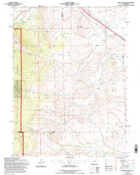
1992 Map of Strouss Hill
USGS Topo · Published 1996About this map
The Overland Trail cuts across the northeastern corner of this high-altitude landscape, marking a historical corridor of westward migration. This 1990s revision by the U.S. Forest Service documents a region where the high plains meet the eastern edge of the Medicine Bow National Forest. The map is characterized by a complex drainage network, including the North Fork, Middle Fork, and South Fork which converge toward the southeast. Settlement is sparse, represented by the Manthos Ranch and Basin Ranch, highlighting the area's continued reliance on livestock grazing and ranching. Mineral interests are evident through several Oil Wells and Prospects scattered across the hills. Prominent local landmarks such as Strouss Hill, Bunker Hill, and Coyote Hill define the topography, while the Straus Ditch No 2 reflects the critical role of water management in this arid Wyoming environment.
Find a feature on this map
28 named features on this map. Tap any name to fly to it.
Don’t see what you’re looking for? This feature index may not catch every label — zoom into the map to look around manually.
Map Details
Editions of this 1992 Strouss Hill Map
This is the sole edition of this map. No revisions or reprints were ever made.
Other maps of this area

1895 · Laramie
USGS Topo · 1:125,000

1902 · Laramie
USGS Topo · 1:125,000

1905 · Laramie
USGS Topo · 1:125,000

1906 · Medicine Bow
USGS Topo · 1:125,000

1906 · Laramie
USGS Topo · 1:125,000

1908 · Laramie
USGS Topo · 1:125,000

1908 · Medicine Bow
USGS Topo · 1:125,000

1954 · Cheyenne
USGS Topo · 1:250,000

1954 · Rawlins
USGS Topo · 1:250,000

1955 · Big Judson
USGS Topo · 1:24,000