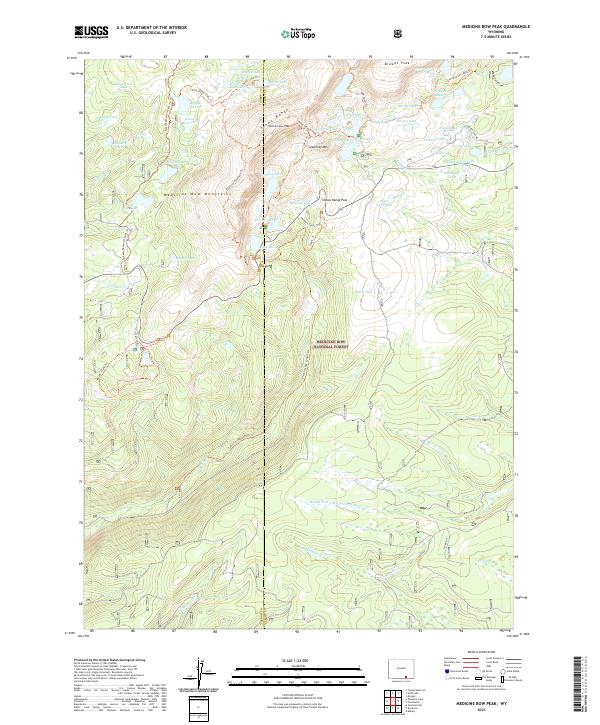
2021 Map of Medicine Bow Peak
USGS Topo · Published 2021About this map
The Snowy Range crests in this portion of the Medicine Bow Mountains, defined by high-altitude glacial lakes and a network of historic trails that served both recreation and early resource extraction. The presence of the Miners Cabin Trl and Tipple Trl near Snowy Range Pass points to the area's mining history, while the concentration of water bodies like Lake Marie, Mirror Lake, and Libby Lake underscores the alpine hydrology of the Medicine Bow National Forest. Moving south from the jagged peaks of Sugarloaf Mtn, the terrain transitions into the expansive Libby Flats, showing the contrast between the rocky summits and the high plateau. Researchers can trace the path of the Medicine Bow Peak Trl as it navigates the ridge between Carbon and Albany counties.
Find a feature on this map
64 named features on this map. Tap any name to fly to it.
Don’t see what you’re looking for? This feature index may not catch every label — zoom into the map to look around manually.
Map Details
Editions of this 2021 Medicine Bow Peak Map
This is the sole edition of this map. No revisions or reprints were ever made.
Other maps of this area

1906 · Medicine Bow
USGS Topo · 1:125,000

1908 · Medicine Bow
USGS Topo · 1:125,000

1954 · Rawlins
USGS Topo · 1:250,000

1958 · Rawlins
USGS Topo · 1:250,000

1961 · Overlook Hill
USGS Topo · 1:24,000

1961 · Sand Lake
USGS Topo · 1:24,000

1961 · Medicine Bow Peak
USGS Topo · 1:24,000
1961 · Phantom Lake
USGS Topo · 1:24,000
1961 · Centennial
USGS Topo · 1:24,000
1961 · Morgan
USGS Topo · 1:24,000