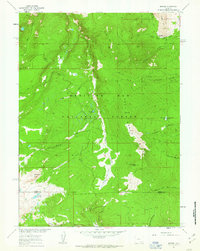
1961 Map of Morgan
USGS Topo · Published 1963About this map
Medicine Bow National Forest dominates this 1961 survey, revealing a high-altitude wilderness defined by the divide between the Carbon and Albany county lines. The small settlement at Morgan and a nearby Lumber Camp suggest a local economy tied to the timber and mining potential of Cooper Hill. The terrain is deeply carved by water, with the Middle Fork Medicine Bow River and South Fork Medicine Bow River draining the western slopes while various forks of Rock Creek and the North Fork Little Laramie River flow east and south. High-altitude landmarks like Rock Creek Point and Rock Creek Ridge overlook a landscape dotted with isolated water bodies, including Crater Lake and Firebox Lake. The network of Jeep Trails and Foot Trails shown here highlights the early 1960s accessibility of this backcountry area for resource management and recreational use.
Find a feature on this map
28 named features on this map. Tap any name to fly to it.
Don’t see what you’re looking for? This feature index may not catch every label — zoom into the map to look around manually.
Map Details
Editions of this 1961 Morgan Map
3 editions found
Other maps of this area

1906 · Medicine Bow
USGS Topo · 1:125,000

1908 · Medicine Bow
USGS Topo · 1:125,000

1954 · Rawlins
USGS Topo · 1:250,000

1958 · Rawlins
USGS Topo · 1:250,000

1958 · White Rock Canyon
USGS Topo · 1:24,000

1958 · Bengough Hill
USGS Topo · 1:24,000

1958 · Arlington
USGS Topo · 1:24,000

1961 · Sand Lake
USGS Topo · 1:24,000
1961 · Strouss Hill
USGS Topo · 1:24,000

1961 · Medicine Bow Peak
USGS Topo · 1:24,000