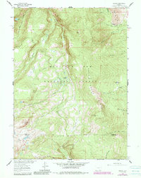
1961 Map of Morgan
USGS Topo · Published 1984About this map
Morgan serves as a lone-named settlement amidst the high-altitude hydrology of the Medicine Bow National Forest. The landscape is defined by the Rock Creek Ridge and the complex drainage systems of the Middle Fork Rock Creek, South Fork Rock Creek, and the headwaters of the North Fork Little Laramie River. A series of mountain water bodies, including Firebox Lake, Sevenmile Lake, and Crater Lake, are connected by a Foot Trail that navigates the difficult terrain between Rock Creek Point and Cooper Hill. The map also captures the political boundary between Carbon and Albany counties, which cuts through this wilderness of glacial lakes and multi-forked streams. The density of named creeks and lakes, such as North Fork Mill Creek and North Twin Lakes, highlights an area intensely focused on water resource management and recreation during the mid-twentieth century.
Find a feature on this map
25 named features on this map. Tap any name to fly to it.
Don’t see what you’re looking for? This feature index may not catch every label — zoom into the map to look around manually.
Map Details
Editions of this 1961 Morgan Map
3 editions found
Other maps of this area

1906 · Medicine Bow
USGS Topo · 1:125,000

1908 · Medicine Bow
USGS Topo · 1:125,000

1954 · Rawlins
USGS Topo · 1:250,000

1958 · Rawlins
USGS Topo · 1:250,000

1958 · White Rock Canyon
USGS Topo · 1:24,000

1958 · Bengough Hill
USGS Topo · 1:24,000

1958 · Arlington
USGS Topo · 1:24,000

1961 · Sand Lake
USGS Topo · 1:24,000
1961 · Strouss Hill
USGS Topo · 1:24,000

1961 · Medicine Bow Peak
USGS Topo · 1:24,000