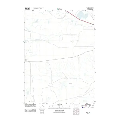
2012 Map of Miller
USGS Topo · Published 2012About this map
Miller and the nearby Windmill Ranch sit within a high-altitude ranching landscape defined by an intricate network of man-made waterways. This 2012 survey illustrates the vital role of irrigation in Albany County, where features like Mammoth Ditch, Poverty Flat Ditch, and the Stewart Canal divert water across the basin to support livestock and agriculture. The topography is dominated by The Big Hollow, a massive wind-eroded depression that forms a distinctive landmark in this part of the Wyoming plains. Scattered across the terrain are natural and modified water bodies, including Knadler Lake, Pilger Lake, and the evocatively named Swedes Cabin Lake. In the southern portion of the map, the elevation rises toward Twin Buttes, providing a clear view of the contrast between the flat, irrigated valley floor and the surrounding high-desert features accessed via Big Hollow Rd.
Find a feature on this map
14 named features on this map. Tap any name to fly to it.
Don’t see what you’re looking for? This feature index may not catch every label — zoom into the map to look around manually.
Map Details
Editions of this 2012 Miller Map
This is the sole edition of this map. No revisions or reprints were ever made.
Other maps of this area

1895 · Laramie
USGS Topo · 1:125,000

1902 · Laramie
USGS Topo · 1:125,000

1905 · Laramie
USGS Topo · 1:125,000

1906 · Laramie
USGS Topo · 1:125,000

1908 · Laramie
USGS Topo · 1:125,000

1954 · Cheyenne
USGS Topo · 1:250,000

1958 · Cheyenne
USGS Topo · 1:250,000
1962 · Miller
USGS Topo · 1:24,000
1962 · Millbrook
USGS Topo · 1:24,000
1963 · Caldwell Lake
USGS Topo · 1:24,000