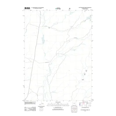
2012 Map of Cottonwood Creek
USGS Topo · Published 2012About this map
N Laramie River dominates this portion of Albany County, winding through a high-plains landscape defined by seasonal watercourses and topographic draws. The northern section is marked by the Bar M Number 3 Reservoir and Hay Draw, illustrating the local reliance on water management in an arid environment. Transportation across this remote ranching country is facilitated by Esterbrook Rd and Garrett Rd, which connect isolated homesteads and pastures. To the southeast, the landscape becomes increasingly detailed with named features like Indian Head Rock and Buckland Draw, alongside the drainage of Cow Cr. This survey captures the rural infrastructure of the early 21st century, where large-scale land management and natural landmarks like Newell Reservoir define the human footprint on the Wyoming range.
Find a feature on this map
16 named features on this map. Tap any name to fly to it.
Don’t see what you’re looking for? This feature index may not catch every label — zoom into the map to look around manually.
Map Details
Editions of this 2012 Cottonwood Creek Map
This is the sole edition of this map. No revisions or reprints were ever made.
Other maps of this area

1954 · Torrington
USGS Topo · 1:250,000

1958 · Torrington
USGS Topo · 1:250,000

1964 · Toltec
USGS Topo · 1:24,000

1964 · Windy Peak
USGS Topo · 1:24,000

1964 · Marshall
USGS Topo · 1:24,000

1968 · Cow Creek Mountain
USGS Topo · 1:24,000

1968 · Cottonwood Creek
USGS Topo · 1:24,000
1968 · Rogers Creek
USGS Topo · 1:24,000
1968 · Garrett
USGS Topo · 1:24,000
1968 · Boot Heel SE
USGS Topo · 1:24,000