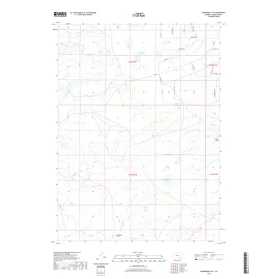
2017 Map of Cannonball Cut
USGS Topo · Published 2017About this map
Cannonball Cut and the dramatic relief of Chalk Bluff define this section of Albany County, where the landscape is shaped by high-altitude hydrology and cattle-country infrastructure. The map reveals an intricate network of water management, visible in the winding paths of Johnston Ditch and Taylor Ditch as they draw from Rock Creek. These diversions are essential markers of the region's agricultural history, supporting ranching operations in a semi-arid environment. Settlement is sparse, represented primarily by a grid of rural routes including Co Rd 61 and various timber-named ways like Tamerack Dr and Pinon Pine Way. The presence of Rock Creek Lakes and Meiser Lake further emphasizes the importance of water storage in this high Wyoming basin, providing a detailed look at the interface between natural drainage and human engineering.
Find a feature on this map
30 named features on this map. Tap any name to fly to it.
Don’t see what you’re looking for? This feature index may not catch every label — zoom into the map to look around manually.
Map Details
Editions of this 2017 Cannonball Cut Map
This is the sole edition of this map. No revisions or reprints were ever made.
Other maps of this area

1954 · Cheyenne
USGS Topo · 1:250,000

1955 · Pine Tree Ridge
USGS Topo · 1:24,000

1955 · Mc Gill Lakes
USGS Topo · 1:24,000

1955 · Sevenmile Spring
USGS Topo · 1:24,000

1955 · Ayres Spring
USGS Topo · 1:24,000

1955 · Cooper Lake North
USGS Topo · 1:24,000

1955 · Lake Ione
USGS Topo · 1:24,000

1955 · Rock River
USGS Topo · 1:24,000

1955 · Cannonball Cut
USGS Topo · 1:24,000

1955 · Wilcox
USGS Topo · 1:24,000