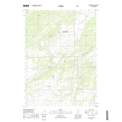
2017 Map of South Mountain
USGS Topo · Published 2017About this map
Medicine Bow National Forest dominates this section of the Laramie Mountains, where the drainage systems of the N Laramie River and Cottonwood Cr carve through a high-altitude landscape. The map centers on significant topographic markers including South Mtn and Bear Head Mtn, defining the watershed divides for numerous seasonal creeks. This 2017 data highlights the sparse human footprint in this part of Albany County, primarily consisting of isolated access routes like Parker Homestead Rd and Cottonwood Park Rd. Local landmarks such as Menter Knob and the Parker Number 1 Reservoir indicate a reliance on water management and grazing in this upland environment. The arrangement of features like Murphy Canyon and Rattlesnake Draw suggests a complex network of canyons and gulches that characterize this transition from mountain peaks to more open parklands.
Find a feature on this map
29 named features on this map. Tap any name to fly to it.
Don’t see what you’re looking for? This feature index may not catch every label — zoom into the map to look around manually.
Map Details
Editions of this 2017 South Mountain Map
This is the sole edition of this map. No revisions or reprints were ever made.
Other maps of this area

1943 · Esterbrook
USGS Topo · 1:62,500

1945 · Esterbrook
USGS Topo · 1:62,500

1954 · Torrington
USGS Topo · 1:250,000

1958 · Torrington
USGS Topo · 1:250,000

1964 · Windy Peak
USGS Topo · 1:24,000

1968 · Cow Creek Mountain
USGS Topo · 1:24,000

1968 · Davidson Flats
USGS Topo · 1:24,000
1968 · Reese Mountain
USGS Topo · 1:24,000
1968 · Fletcher Park
USGS Topo · 1:24,000
1968 · South Mountain
USGS Topo · 1:24,000