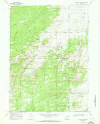
1968 Map of Fletcher Park
USGS Topo · Published 1972About this map
Medicine Bow National Forest dominates this high-altitude terrain, where the boundary between Albany and Platte counties cuts through a landscape defined by dramatic rock formations and mountain drainage systems. By the late 1960s, the area remained largely oriented around seasonal camps and small-scale operations like Hanks Sawmill. The North Laramie River winds through the central forest, fed by numerous tributaries including Claude Irvine Creek and Brandel Creek. Landform markers such as Indian Head Rock and Chimney Rock served as crucial navigational aids for those traveling along the Van Ortwick Hill Road or following the many pack trails. Settlements are sparse, represented by Cottonwood Park, Fletcher Park, and the specialized facilities at Camp Grace and Camp Hill, reflecting a territory primarily used for resource extraction, forestry, and outdoor recreation.
Find a feature on this map
33 named features on this map. Tap any name to fly to it.
Don’t see what you’re looking for? This feature index may not catch every label — zoom into the map to look around manually.
Map Details
Editions of this 1968 Fletcher Park Map
3 editions found
Other maps of this area

1943 · Esterbrook
USGS Topo · 1:62,500

1945 · Esterbrook
USGS Topo · 1:62,500

1950 · Cottonwood Falls
USGS Topo · 1:24,000

1951 · Cottonwood Falls
USGS Topo · 1:24,000

1953 · Hightower SW
USGS Topo · 1:24,000

1953 · Johnson Mountain
USGS Topo · 1:24,000

1954 · Torrington
USGS Topo · 1:250,000

1958 · Torrington
USGS Topo · 1:250,000

1968 · Davidson Flats
USGS Topo · 1:24,000
1968 · Reese Mountain
USGS Topo · 1:24,000